57 East Asia: Physical Geography I – Taklamakan Desert
The Taklamakan Desert is one of the world’s more interesting deserts, yet is lesser known than many other deserts. At over 100,000 square miles, this desert is not small, but perhaps its isolated location in the western interior of China contributes to this relatively unfamiliar status.
ACRONYM 
STREWN
S Sand
T Toponym
R Rain Shadow
E Eolian
W Winter
N No One
STREWN – to be dispersed, as if scattered
ES is for Eolian Sand
Eolian means wind-formed. Indeed, since deserts are short on water, those landscapes irregularly suffer from water erosion. Instead, the relatively mild erosive powers of wind slowly change and move desert lands. The surface of the Taklamakan Desert is dominantly sand, composed of debris broken down from pebbles, of alluvial material carried down the mountains by snow melt, and of windblown material. As wind is not a powerful erosive force, windblown material is friable (quite lightweight to move with wind); indeed, sand is a useful selection.
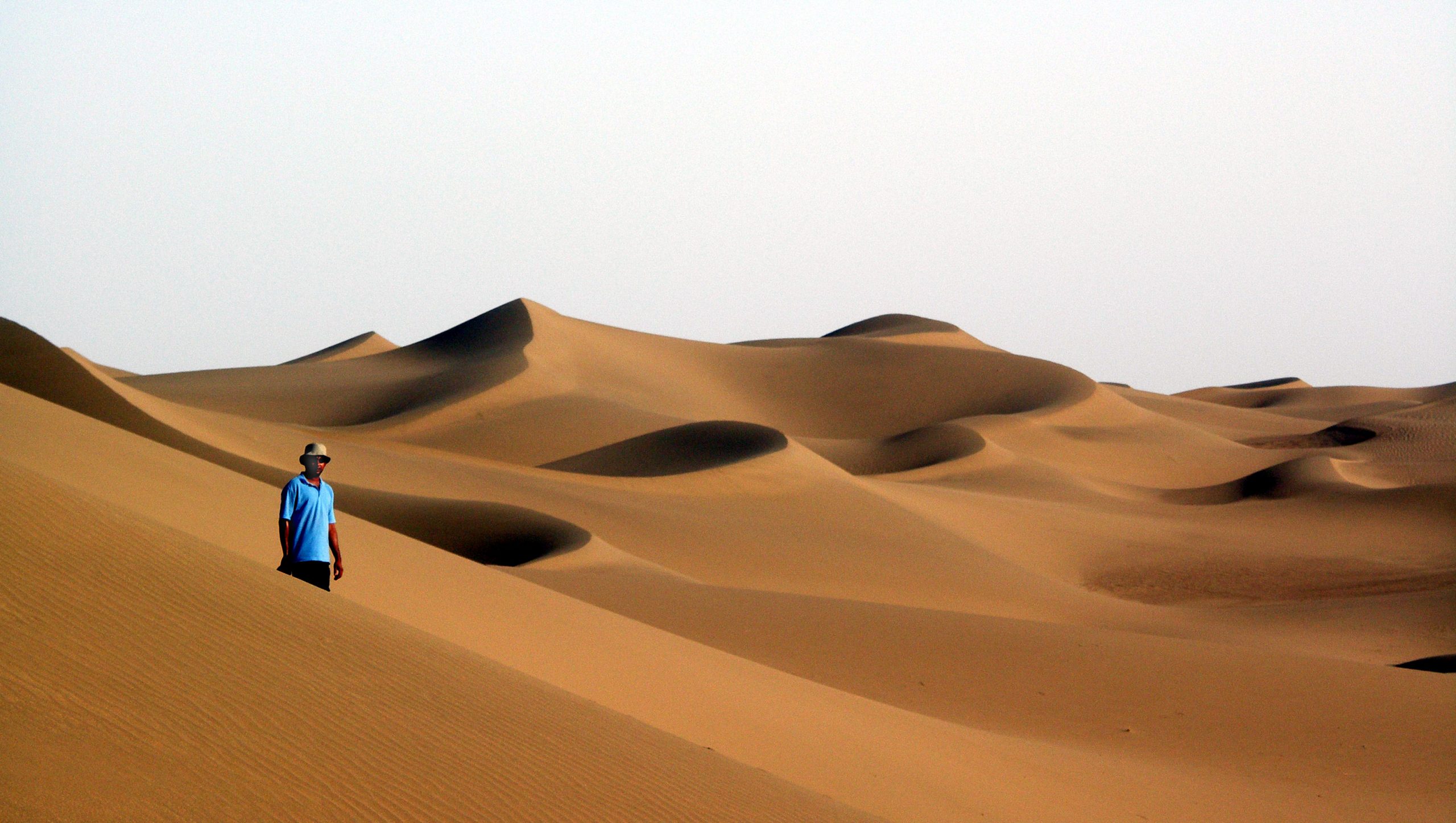
Photo by Prashant Ram on Flickr.
Indeed, sand is the primary surface of the Taklamakan Desert. As wind moves the surface landscape of the Taklamakan Desert, sand dunes are common throughout. Layers of sand are deposited in even to a depth of 1000 feet, while individual dunes may reach 500 feet in height and over 1000 feet in width. A variety of dune types, including transverse and longitudinal dunes, can be found there.
T is for Toponymy.
Let’s consider the features of the Taklamakan Desert. We shall begin with the toponymy or place name. Though there are different ideas about the sources of takla, makan is Persian for place. The general connotation of the name Taklamakan is that the place is forbidding and not a safe place for passage. While some desert areas in the world do have long histories of travel and trade caravans, crossing the Taklamakan Desert should be avoided as a trade route or as an area for any transportation.
Additionally, we have a bit of trouble spelling the place name. This is a problem of spelling foreign place names in the English language. For many Indo-European languages that have similarities to English and use the Latin alphabet, this spelling issue is absent. However, transliterating names from other alphabets (Arabic, Cyrillic, …) or character-based systems into English is a problem. Given this desert’s location in China, obviously Chinese characters are used to state the name; therefore, there may be an issue in spelling the place name in English. While Taklamakan is most common and thus used in this chapter, there are variations such as Taklimakan or Teklimakan or Takli Makan or Takla Makan.
R is for Rain Shadow
The Taklamakan Desert is an extreme example of the consequences of orographic precipitation; specifically, it is a rain shadow desert. As described in Chapter 6, orographic precipitation is the common phenomenon where rain (or snow) occurs dominantly on one side of mountains, leaving the other side mainly dry. As clouds go over the mountain peaks, they may release some precipitation, before descending and evaporating. Thus, the Taklamakan Desert receives some water flow from mountain sides, usually as snow melts there.
Here the rain shadow of orographic precipitation is caused by mountains that nearly surround the Taklamakan Desert. The southern edge of the desert is dominated by the Kunlun Shan range (shan is the Chinese word for mountain). In the north there are the Tien Shan. To the west are the Pamir Mountains. To the east there is a small passageway, not blocked by mountains; however, it is far from any ocean breezes and the standard west-to-east weather patterns do not bring any rain east-to-west into the Taklamakan Desert. Thus, the Taklamakan Desert is caused by the perfect storm of orographic precipitation, as the surrounding mountains pour almost all the rain and snow not into the Taklamakan, but on the other sides of the mountains.
W is for Winter
Recall that deserts do not have to be hot with blazing sunshine. Deserts simply are dry. While the Taklamakan Desert does have hot summer temperatures, it also features cold winters. For comparison, Chicago’s average low temperature in January is 17°F, while the Taklamakan Desert’s average overall winter temperatures are 11-14°F. Note that the center of the desert is a 39° N latitude, compared to Chicago’s 41° N latitude. The Taklamakan Desert’s far interior location, elevations between 2900 and 4900 feet, and relative position not too far from Siberia all contribute to its cold winters.
N is for No One
Basically, in most areas no one lives in the Taklamakan Desert. There have been attempts at agriculture, but most were short-lived and fruitless. Only areas with direct and consistent water flow from the mountains can support human populations. For instance, in the far west of the Taklamakan Desert, Yarkand (or Shache) County held 850,000 people in 2015, but historically was on a branch of the Silk Road. Yarkand County seems incredibly high in population, given the context; however, recall that with China’s 1.4 billion people, any populated area seemingly becomes quite crowded and populous.
STREWN is our acronym for the Taklamakan Desert. What is strewn across this landscape?
Eolian Sands – yes, strewn
No One – empty spaces, strewn
Winter – cold temperatures, strewn
Rain Shadow – shadow, strewn
Toponymy – various spellings, strewn
Did you know?
Although an obscure language, the Central Asian Dungan language uses the Cyrillic alphabet, naming the Taklamakan Desert as Такәламаган Шамә.
Pamir, as in the Pamir Mountains, is a type of plateau or valley surrounded by mountains.
Cited and additional bibliography:
Ram, Prashant. The Taklamakan Desert. photo, 1 June 2013. Flickr, https://www.flickr.com/photos/stupid_dream/8863637977/. Attribution-NoDerivs 2.0 Generic (CC BY-ND 2.0)
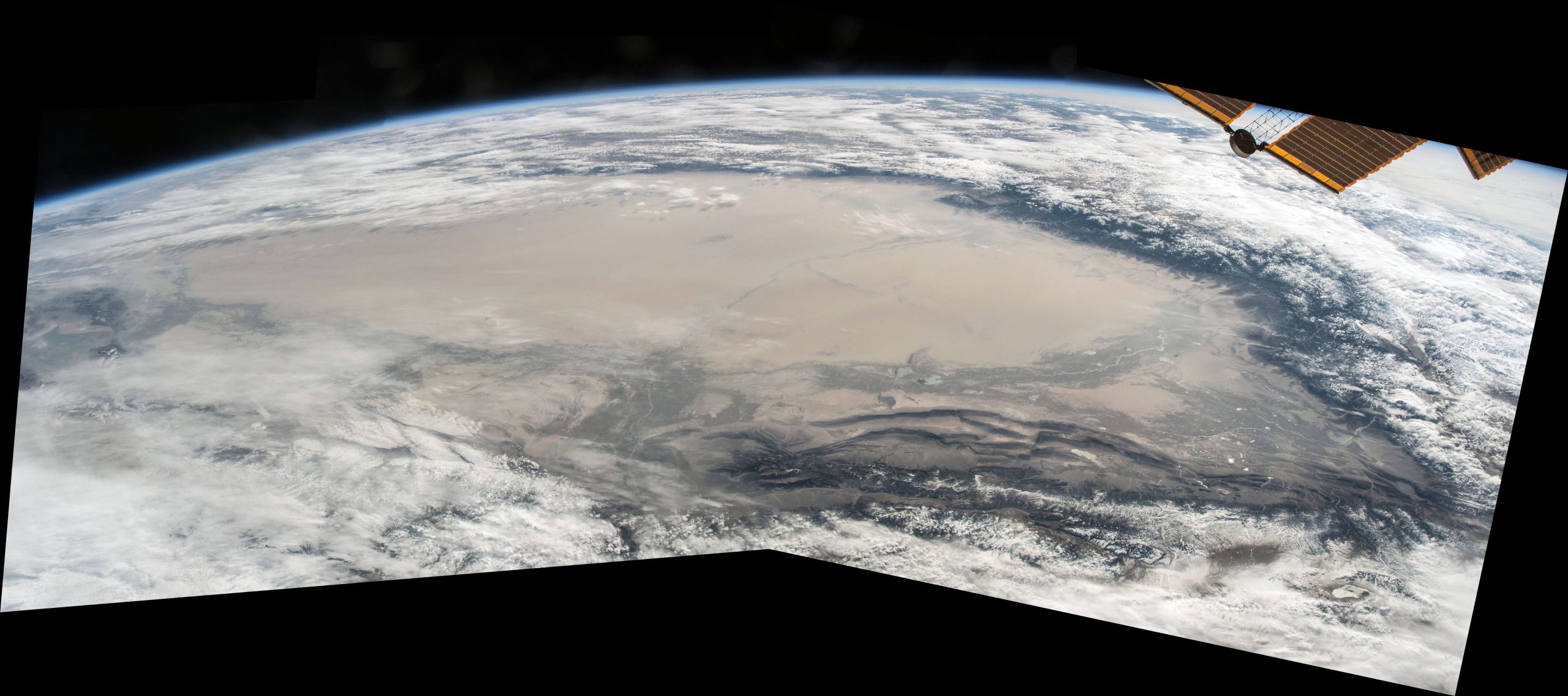
Rankin, Stuart. Composite satellite image of the Taklamakan Desert. photo. 11 November 2015. Flickr. https://cod.pressbooks.pub/app/uploads/sites/89/2021/09/TaklamakanSatelliteStuartRankinFlickr-scaled.jpg . Attribution-NonCommercial 2.0 Generic (CC BY-NC 2.0).
