36 Sub-Saharan Africa: Historical Geography II – South Africa

The Dutch founded a colony near the Cape of Good Hope, on Africa’s southern coast, in the 1600s. Initially intended to serve as a supply station for ships sailing between the Netherlands and Indonesia, the Dutch discovered that the Cape possessed a climate suitable to European-style agriculture. Soon, a large number of farmers emigrated from the Netherlands to South Africa, creating a rare European settler colony on the African continent.
These settlers were often referred to as Boers, from the Dutch word for farmer. For the next two centuries, the Boers lived under distant rule from the Netherlands, and eventually began to develop their own identity and culture, including a distinct dialect of Dutch, called Afrikaans. Over time, they began to refer to themselves as Afrikaners, which simply means “Africans” (similar to the Europeans who migrating to the Americas and calling themselves as “Americans”).
Of course, the Cape region had been inhabited by Black Africans prior to the arrival of the white settlers. The Boers displaced many of them, in the same way European settlers displaced indigenous people in the Americas, Australia, and New Zealand. The Dutch Afrikaners also enslaved Black Africans, including some original inhabitants of the Cape region, although many of the enslaved were imported from elsewhere on the continent.
In 1803, the British seized control of the Cape from the Netherlands. The Afrikaners bristled under British rule, and grew even more resentful as a wave of British settlers moved to South Africa. In 1833, Britain abolished slavery in all of its colonies, and many Afrikaners decided to leave the Cape region altogether. Thousands migrated into the “high veldt,” which are the northern sections of modern South Africa. As they had done in the Cape region two centuries before, the Afrikaners displaced indigenous people and seized their land. They established a number of independent countries, most notably Transvaal and the Orange Free State.
In the late 1800s, British explorers discovered tremendous deposits of gold and diamonds in the Afrikaner republics. This would lead to the Boer Wars of the late 1800s and early 1900s, in which the British battled Afrikaners for control of the high veldt. The British defeated the last of the Boers in 1902. Three years later, the Union of South Africa was formed, joining the Afrikaner republics and the Cape region together into one British colony. It was granted independence from Britain in 1910, although it still recognized the British monarch as its symbolic head of state (much like Canada and Australia).
Despite immigration from Britain and other European countries, the Dutch Afrikaners still made up the majority of South Africa’s white population. And despite centuries of slavery, segregation, mistreatment, and displacement, Black South Africans still greatly outnumbered white South Africans. In the 1950s, Black South Africans accounted for 70% of the country’s population, while white people accounted for just 15%. People of mixed ancestry, known in South Africa as the “colored,” made up 8% of the population. Asians accounted for about 2% of South Africa’s population, and were mainly immigrants from British India (today’s India, Pakistan, and Bangladesh).
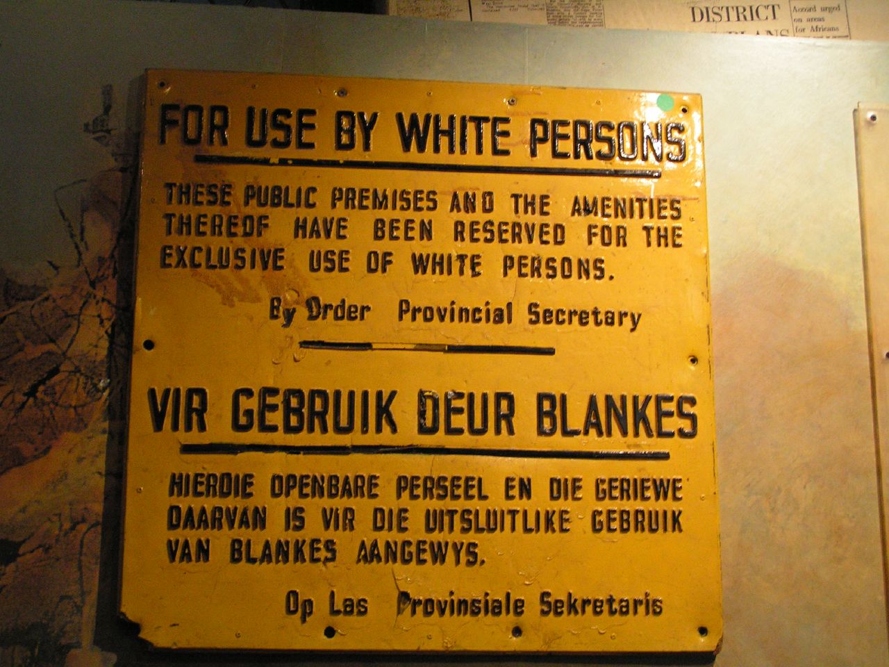
During South Africa’s first few decades of independence, segregation of the races was the norm, and white South Africans held enormous privileges compared to non-white South Africans. In 1948, the Afrikaner-dominated National Party came to power, and soon implemented a policy known as apartheid (meaning “apartness” or “separateness”). Much of apartheid was simply the legal codification of long-standing practices of racial discrimination, but it also contained new measures to ensure white superiority. In 1950, South Africans were forced to register with the government by race – as white, colored, black, or Asian, and were granted certain rights or restrictions based on their registered race. Apartheid was generally divided into three distinct schemes – “petite apartheid,” “meso-apartheid,” and “grand apartheid” – which effectively translate as small, medium, and large apartheid.
Petty apartheid laws governed the day-to-day actions of people based on race, and were similar to the “Jim Crow” laws of the segregated American South. Government buildings, busses, restaurants, restrooms, and other public facilities were divided into distinct sections for white and non-white patrons, and non-white South Africans excluded from some facilities altogether. Separate public-school systems were established, with the Black schools primarily training their students for manual labor. Interracial marriage was banned, and laws were established to treat anyone who publicly criticized apartheid as a communist and an enemy of the state.
Meso-apartheid laws divided South African cities into sectors based on race. People of one race were restricted from living, running businesses, or owning property in a sector designated to another race. As one might expect, most of the land, and certainly the most desirable land, was designated for white occupation. Many non-white South Africans were uprooted from long-established neighborhoods and forced to move elsewhere. Non-white South Africans were still permitted to work in white areas, but were now required to carry passbooks, a sort of domestic passport, detailing their place of occupation and their working hours. Severe punishments were meted out to non-white South Africans who were found in white areas without official permission.
Grand apartheid laws established separate homelands for Black South Africans, with the ultimate goal of excluding them from the South African state entirely. Ten rural Bantustans (Black homelands) were designated for occupation by Black South Africans. Similar to Native American reservations of the United States, the Bantustans were usually on marginal, unvaluable land. And, although Blacks made up three-quarters of the country’s population, the Bantustans accounted for only one-fifth of the country’s land area. All Black South Africans, regardless of where they lived, were given citizenship in one of the Bantustans, and were stripped of their South African citizenship. The ultimate goal was to grant the Bantustans full independence, and create an entirely white South Africa. Grand apartheid was largely a failure because the South African economy depended on Black labor in major cities and other areas far removed from the Bantustans.
An anti-apartheid movement began to gain momentum in the 1960s, and even some white South Africans began to vocalize their discontent with the policy. Peaceful demonstrations against apartheid were often met with police violence. Black civil rights leaders were jailed, including one of its most prominent figures. Nelson Mandela, a leader of the anti-apartheid African National Congress, was convicted of sedition in 1962 and sentenced to life in prison.
Cartography by Steve Wiertz.
Slowly, the international community began to take notice. South Africa was forced out of the British Commonwealth in 1961, and the United Nations officially condemned apartheid in 1973. In 1985, Britain and the United States placed economic sanctions on South Africa. Under growing internal and external pressure, South African President F.W. de Klerk ordered Nelson Mandela’s release from prison in 1990. Apartheid officially ended the following year. In 1994, the first multi-racial elections were held in South Africa, and Mandela was elected president.
Today, South Africa is Sub-Saharan Africa’s most prosperous country, accounting for one-third of the region’s economic output. And in the years since the end of apartheid, a number of Black South Africans have to come to share in that prosperity. Still, it has been extremely difficult for the country to wipe away centuries of institutionalized racial discrimination in employment, housing, and education. Although Black South Africans today make up 80% of the country’s population, they still control less than 20% of the country’s wealth.
Did you know?
Cited and additional bibliography:
andavis86. Muizenberg – South Africa. Photo, 20 May 2013. Flickr, https://www.flickr.com/photos/andavis86/8838143526/. Attribution-NonCommercial-NoDerivs 2.0 Generic (CC BY-NC-ND 2.0).
Pluck, Kevin. Whites Only. Photo, 30 July 2004. Flickr, https://www.flickr.com/photos/yaaaay/10142774/. Attribution 2.0 Generic (CC BY 2.0).
Wiertz, Steve. South Africa. College of DuPage GIS class.
