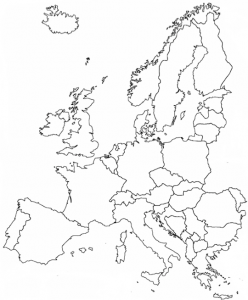
48 Europe
How do we define this region?
“Geography is an earthly subject, but a heavenly science.”
– Edmund Burke, Irish statesman and philosopher
Regional geography studies the people and places of a cohesive region. A “region” is defined to be an area with multiple shared elements over a range of categories, including both physical and human geographic characteristics. The secret of creating a region, which is a human construct not a naturally begotten unit, is to cluster together as many similarities as possible, while excluding geographic differences.
In some cases, the determination of a geographic region is simple. For Europe, quite a bit of the decision-making is accomplished simply by noting where the land ends and meets large bodies of water.
As we understood with our definition of the Western World, nearly all of Europe’s countries meet the three noted criteria – contiguity, Christianity, and Indo-European language. Much is Europe’s landscape is distinctive by the frequent pattern of islands, peninsulas, and mountains. In fact, how many European countries lack all three of these physical landforms? I count these (excluding micro states) – Lithuania, Belgium, Luxembourg, Bulgaria, Moldova.
Historians will recount certain patterns of shared experiences among European countries. Some elements of this history will explain how Europe has the world’s predominant share of nation-States.
Fundamentally though, there are some clear limitations of physical geography on what can be called Europe. To the west, there is the clear boundary of the Atlantic Ocean. The only worthwhile questions for westward inclusion in Europe are the islands of Iceland and Greenland. Iceland has obvious cultural links with much of Northern Europe; in fact, we count Iceland in Scandinavia. Greenland is an autonomous territory of Denmark and thus arguably belongs in Europe. Greenland’s landmass is physically part of the North American continent, but generally has been considered part of Europe. Or, frankly, sometimes Greenland simply is ignored.
To the north, there is the Arctic Ocean. In this direction, the European landmass terminates with the northern reach of Norway. Additionally, Norway owns the islands of Svalbard, farther north.
To the south, there is the Mediterranean Sea. Clearly, there is Europe on one side and Africa on the other. What about the islands of the Mediterranean? European countries have long owned most of these islands – Balearic (Spain), Corsica (France), Sardinia and Sicily (Italy), Crete and many (Greece). Cyprus is effectively partitioned with a Turkish north, but is a member of the European Union. Malta is an independent country with a mix of ethnicities, but also is a member of the European Union.
The eastern edge of Europe is the controversial side. As you will learn in the reading on the Russian Domain, this textbook argues that Russia belongs either as its own region or as a slightly larger region adding Ukraine, Belarus, Armenia, Georgia, and possibly Moldova. Thus, Europe ends in the east with the wall of Slavic countries – Russia, Belarus, and Ukraine.
Some may ask if Turkey could be a southern or eastern member of Europe. Indeed, Turkey has expressed interest in joining the European Union, though that inclusion is nowhere near imminent. Perhaps reluctantly, geographers would understand that Turkey belonging to the European Union would qualify Turkey as in Europe. In the meantime, however, Turkey belongs in the Middle East (or Southwest Asia). Although Turkey practices a very secular approach to Islam, its religious affiliation matches the dominant religion of the Middle East and not that of Europe. The Turkish language is not an Indo-European language, but falls in the Turkic language family, like several languages in Central Asia. A small portion of Turkey’s landmass lies across the Bosporus Strait and thus shares land borders with Greece and Bulgaria. Even so, the vast majority of Turkey’s land is to the east and historically has been considered part of Asia.
Given these exclusions of Turkey and of the Russian Domain from Europe, this means that the Black Sea serves as a major water border for part of Southern Europe and part of Eastern Europe.
Did You Know?
Spain does have two urban exclaves – Ceuta and Melilla – that are on the African coastline, otherwise within the country Morocco. Spain’s Canary Islands are 62 miles west of the southern shores of Morocco. With Spanish colonial history and control, these islands are counted as part of Europe.
The Faroe Islands are roughly triangulated – east of Iceland, north of Scotland, and west of Norway. Like Greenland, these islands are an autonomous territory of Denmark. They are always considered as within Europe, though oddly they are not counted in the European Union.
The nine islands of the Azores rest in the Atlantic Ocean, 850 miles west of Portugal. As an autonomous region of Portugal, the Azores also are in Europe.
Mayotte is a French island in the Indian Ocean. As such it has status as an outermost region (OMR) of the European Union, but is not part of Europe. There are several other similar cases. France’s New Caledonia in the Pacific Ocean counts in the category overseas countries and territories (OCT), similarly giving it rights in the European Union, but not making it part of Europe. Here too, there are several other cases, including the former Netherlands Antilles.


