101 Russian Domain: Physical Geography – Bering Strait
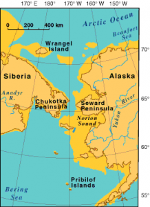
By geographic definition, a strait is a narrow passage of water that separates two large landmasses. The Bering Strait meets this definition, for it is a stretch of water about 58 miles across, separating Cape Prince of Wales, the westernmost point of Alaska (USA), from Cape Dezhnev, the easternmost point of the Far East region of Russia.
ACRONYM 
CRIPPLE
C Caribou
R Resources
I Isolated
P Prison Camps
P Permafrost
L Land Bridge
E Exploration
The features of the broader region near the Bering Strait can be remembered with the acronym CRIPPLE, perhaps appropriate given the difficulties of life there.
C – Caribou
Few people chose to live in this extreme location of the Russian Far East. Historical patterns of in-migration of Russians into Siberian locations have made Russians the majority population. However, the ethnic natives in the region, among the so-called “numerically small peoples” of Russian/Soviet censuses, remain the few who practice outdoorsmen habits in the Bering Strait region. The most numerous here are the Chukchi, whose name is derived from the term for “rich in reindeer.” Indeed, caribou herding remains a way of life, sometimes supplemented by fish from the cold coastal waters.
R – Resources
As is true with Siberia and the Far East in general, the Bering Strait region possesses a variety of resources, such as tin, lead, zinc, gold, and coal in the Chukchi Peninsula. The challenging climate and landscape causes great difficulties in extracting and transporting these resources, prompting high wages for those willing to work with these resources.

I – Isolation
In terms of different measures of isolation, the Russian shores along the Bering Strait may be the world’s most isolated continental location.
Accessibility right at the Bering Strait is limited to tiny coastal locations of Uelen and Provideniya. Farther down the coast is the town of Anadyr (about 15,800 people) which provides port and airport service.
Population density in the region is exceedingly sparse, fewer than one person per square mile for rural areas. Distance to large cities measures in the hundreds and even thousands of miles.
P – Prison Camps
In Tsarist and more so in Soviet times, Siberia was a notorious location for the exiling of criminals and political prisoners. Soviet prison camps went almost to the waters of the Bering Strait itself. Of course, isolation often is considered desirable for prisons. In addition, prison labor here contributed to resource extraction and transportation construction, without regard for the miserable conditions.
P – Permafrost
Nearly half of the Russian landmass is permafrost, permanently frozen soil. Far northern locations like the Bering Strait region uniformly have permafrost. Even the warming effects of the sea do little to reduce the frigid conditions of the region. Short summers and winters reaching –40°F chill this tundra region. Wind chill in nearby Anadyr has reached –90°F.
L – Land Bridge
Anthropologists tell us that during the world’s last ice age, which peaked at about 18,000 BC, native peoples from Siberia and the Far East crossed the Bering Strait into Alaska. Within this time frame lower water levels in the Bering Strait likely would have exposed the continental shelf, so that people could have crossed on land or ice bridges. These peoples became the ancestors of the native peoples of North and South America.
There has long been interest in recreating this bridge, but now in terms of a transportation link between America and Russia. In 1890, William Gilpin, the Governor of Colorado, suggested a grand plan to connect all the great cities of the world by means of railroads. Thus, the idea was tossed around in the early days of the 20thcentury; however, disinterest and opposition from American President Theodore Roosevelt and from the Russian ruling elite slowed enthusiasm greatly.
A railroad bridge? A rail tunnel? Both? With conduits for oil and natural gas? These ideas popped up now and then throughout the 20thcentury. Currently, some experts continue to devise plans. The InterContinental Railway group has a plan that would cost over $100 billion. It would include a tunnel beneath the Bering Strait, reaching more than 160 feet deep. With this seventy-mile long tunnel, railroad tracks would be added to reach from Yakutsk, Russia, to Fort Nelson, Canada. These rail sites already connect to tracks throughout Russia and all across Canada and the United States.
See map and plan at: https://static1.squarespace.com/static/58b72801e3df2821397e13cb/t/5b92012670a6adc1daab0d65/1536295261952/ICR_WTC_mid-res.pdf
E – Exploration
Russian settlement reached Anadyr in 1649, with the exploration of Russian navigator Semyon Dezhnev. In 1725 Tsar Peter the Great sent Vitus Bering to captain a navel expedition to chart Siberia’s northern shores. Though it took Bering 3000 miles and three years of sailing to reach the region, he did found no land bridge to Alaska, but did chart Russian coastline and did discover that Siberia extended farther eastward than previously understood.
Did You Know?
The International Dateline runs through the Bering Strait.
Vitus Bering was a Dane who was recruited as a young man in 1704 to join the new Russian Navy. In 1741 on another expedition to the strait now bearing his name, he was shipwrecked by stormy weather and died on the small island that also bears his name, Bering Island, just east of the Kamchatka Peninsula.
“Bering Strait” was the name of a popular music group, consisting of several young classically trained Russian musicians who grew enamored with American bluegrass music and emigrated to the United States to find a few years of success with their country, bluegrass, and pop tunes. However, these Russian musicians are not from the Bering Strait region, but are from Obninsk, near Moscow.
For a quick look at how far a rail line across the Bering Strait could go, look at: https://i.redd.it/x4dl2058q2651.png
Cited and additional bibliography:
DeGeorge, Krestia. 2019. “Is the World Ready for a Bering Strait Rail Link between Alaska and Russia?” ArcticToday. April 1, 2019. https://www.arctictoday.com/is-the-world-ready-for-a-bering-strait-rail-link-between-alaska-and-russia/?wallit_nosession=1.
Humber, Yuriiy, and Bradley Cook. 2007. “Longest Tunnel to Connect Russia and Alaska.” Red Orbit, April. http://www.redorbit.com/news/science/906923/longest_tunnel_to_connect_russia_and_alaska/index.html.
“R/MapPorn – A Europe–U.S. Superhighway Proposed by the Former President of Russian Railways.” 2020. Reddit. June 20, 2020. https://www.reddit.com/r/MapPorn/comments/hcmzpk/a_europeus_superhighway_proposed_by_the_former/.
Shirk, Adrian. 2015. “What If You Could Drive From Paris to New York?” The Atlantic. July 1, 2015. https://www.theatlantic.com/technology/archive/2015/07/superhighway-bering-strait-new-york-paris/397370/.
