9 Urban Geography –
Concepts and Terminology

Urban geography is the study of cities. Geographers examine the factors that lead to the location and relative size of cities, and also the complex processes that shape the nature of individual urban areas.
The History of Urbanization
Humans took their first step toward urbanization over 12,000 years ago with the development of agriculture. As the domestication of plants and animals grew more and more sophisticated, a food surplus began to develop in some societies. This surplus allowed a few members of these societies to step away from agriculture and develop specialized occupations. The first non-farmers were likely political and religious leaders, soldiers, artisans, merchants, and scholars. Whatever their occupations, they began to live in concentrated settlements around 4000 BCE, and the first cities were born.
A city was (and still is) a dense settlement of people working in specialized occupations. The rural area surrounding a city is known as its hinterland. Hinterlands have long been focused on the primary sector – agriculture, timber, mining, and other forms of raw materials extraction. The hinterland supplied these raw materials to the city, and the city provided goods and services for its hinterland. Over time, cities grew larger and more complex, as civilizations linked multiple cities and their hinterlands to form larger states and empires. Since the dawn of urbanization, cities have evolved into centers of trade, invention, commerce, education, politics, religion, and culture.
Still, for most of human history, the bulk of labor was needed in the primary sector, so the vast majority of humans remained rural. As late as 1800, fewer than 5% of humans lived in cities. A century later, the global urbanization rate was still under 20%. But the process that would create an urban world was well underway. The Industrial Revolution had two profound impacts on urbanization rates. The first was the mechanization of agriculture, which slowly reduced the need for labor in rural areas. The second was the rise of the factory. It has always made good economic sense for factories to cluster together, which means that factories were best suited for large urban areas.
Urbanization accompanied industrialization throughout the world. The industrialization of the United States was in full swing by 1920, when its urban dwellers first accounted for more than half the population. Since then, the U.S. labor market has increasingly shifted from manufacturing to services and information, but these jobs are also primarily located in cities. At the same time, jobs in the primary sector, such as agriculture, have continued to dwindle, furthering rural-to-urban migration. By 2010, the U.S. population was more than 80% urban.
The rest of the world has followed the same trend. By the close of the 20th century, the world was nearly half urbanized. In 2007, for the first time in human history, more people worldwide lived in cities than in rural areas. Since more developed economies have more jobs in manufacturing, service, and information sectors, they tend to have more urbanized populations. The five countries with the highest standards of living (according to the Human Development Index) are Norway, Australia, Switzerland, Denmark, and the Netherlands. These countries are, on average, about 84% urban. Less developed economies tend to feature more jobs in the primary sector, and are thus more rural. The five poorest countries on earth are Niger, the Central African Republic, Eritrea, Chad, and Burundi. These countries are, on average, only about 23% urban.
Even though less developed countries tend to be less urban, some of the fastest growing cities are found in the developing world. This is because nearly all economies on earth are seeing a decline in jobs in the primary sector, and because the most rapid population growth is happening in developing countries. Two cities in Africa illustrate this rapid trend. Kinshasa, in the Democratic Republic of Congo, was home to just 450,000 people in 1960. By 2000, its population had swelled to 4.6 million. Over the next decade, the population nearly doubled, to 9 million. Lagos, Nigeria, had a population of 230,000 in 1950. By 1960, the population had quadrupled to 1 million. In 2000, the population stood at 11 million.

Urban Regions
A city is as an area of dense settlement that falls within legally defined municipal boundaries. Cities are often surrounded by suburbs. Suburbs are generally defined as smaller municipalities and settlements of medium population density that are adjacent to a large city, and part of its economic market. Some suburbs are primarily residential. Such bedroom communities are home to those who commute to work in the city or in another suburb. Some suburbs, called edge cities, are more economically complex. They are usually relatively new developments, and contain residential areas, but also the same kinds of economic landscapes traditionally associated with urban centers, such as office buildings, shopping and entertainment districts, and even factories. A metropolitan area, or “metro area” is the urban region occupied by a large city and its suburbs.
A metropolitan conurbation (also known as a metropolitan agglomeration) is an area where two or more metropolitan areas grow large enough to overlap one another. Examples of prominent metropolitan conurbations in the United States include the overlapping metro areas of New York and Newark; Washington and Baltimore; Boston and Providence; and San Francisco, San Jose, and Oakland.
A megalopolis is an urban region where several metropolitan areas and conurbations form a large, nearly continuous urban region. One example of a North American megalopolis is found along the lower Great Lakes. Extending roughly from Milwaukee to Buffalo, it includes such metropolitan areas as Chicago, Detroit, Windsor, Toronto, Cleveland, and Pittsburgh. Another megalopolis is located in the American Northeast. Sometimes referred to as “Boswash,” it extends from Boston to Washington, and includes such metro areas as New York, Baltimore, Philadelphia, and Providence.
Site and Situation
A city’s location and relative size are often determined by its site and situation. A city’s site refers to the properties of its physical environment. A city’s situation refers to its spatial relationship to other places. Examples of the importance of both site and situation can be found in the northeastern United States. Four of the largest cities in that region – New York, Philadelphia, Boston, and Baltimore – are located on large harbors. These excellent harbor sites stimulated economic activity that enabled these cities to become important commercial and transportation centers. But of all of them, New York had the best situation. Located at the mouth of the Hudson River, New York had easy access to upstate New York and, with the completion of the Erie Canal, the Great Lakes. New York’s situation enabled it to tap into the growing economy of the Midwest. Its situational advantage over other east coast cities is the primary reason for its eventual economic and demographic dominance of the region.
Urban Form
A significant focus of urban geography is urban form. This is the examination of the geographic distribution of people, activities, and landscapes that make up a city. A city’s physical environment may play a large part in shaping its urban form. For example, cities situated in lowlands will often take different forms than those situated in hilly or mountainous areas. The presence of a major river, a lake, or an ocean will also have a significant impact on a city’s form. History plays a role as well. Cities that have existed for hundreds or even thousands of years will obviously look different from much newer cities. In some cities, newer developments are constructed separately from older parts of the city. In others, some of the newest buildings rise alongside some of the oldest. Cultural patterns will often manifest themselves on the urban landscape, with certain sections of a city bearing the imprint of particular ethnic groups. Politics will also shape urban forms. In Europe, feudal governments, fascist governments, and communist governments all left unique urban imprints, and European empires left their unique colonial imprint on cities all over the world. Population density is one of the most easily detected variations in urban form.
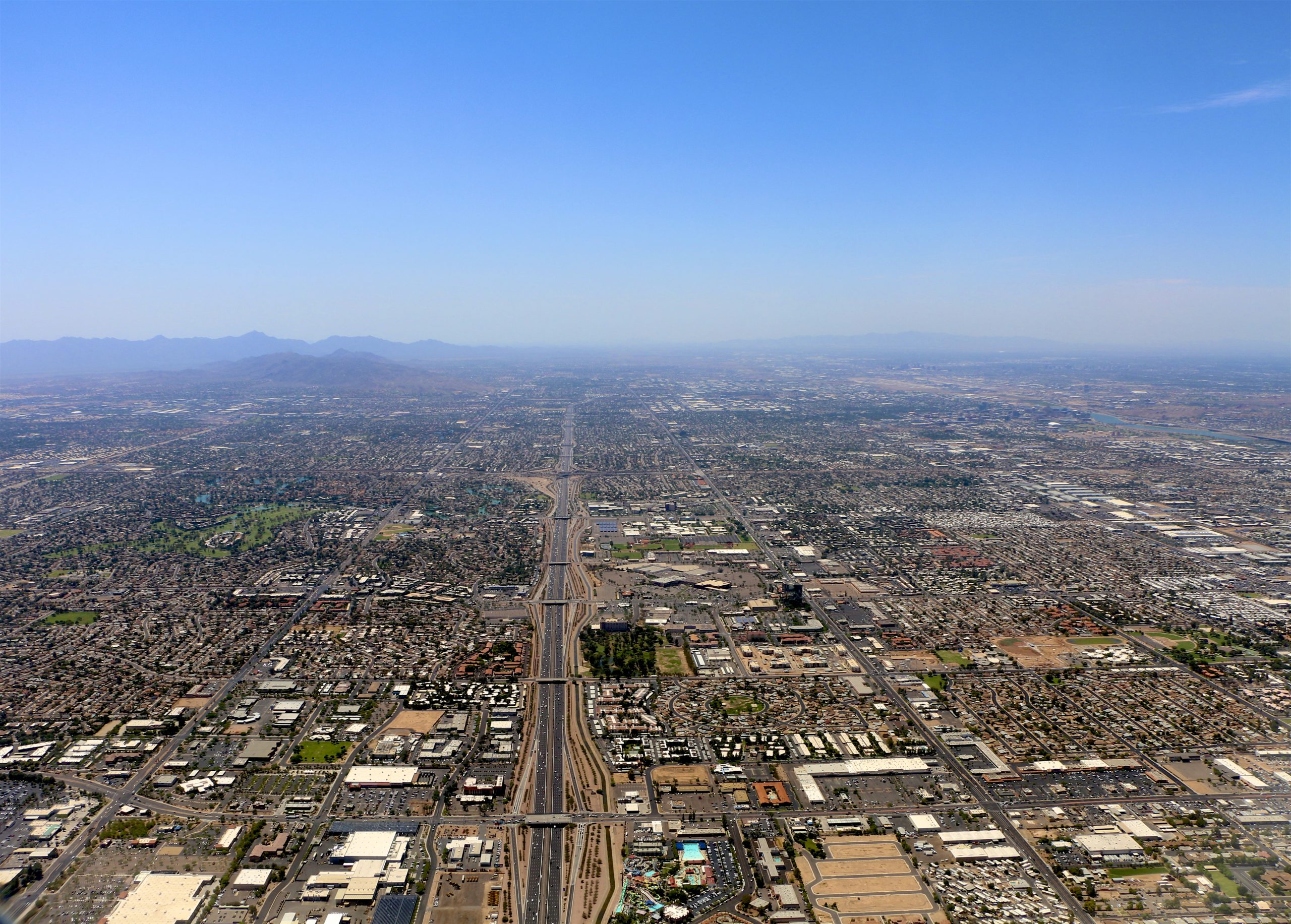
Sprawling Phoenix, Arizona, with a population density of about 3,100 people per square mile, certainly has a different form than jampacked Manila, the capital of the Philippines, which is home to more than 107,000 people per square mile.
Probably the most important force that shapes urban form is economics. The heartbeat of a city is found in its trade, commerce, and manufacturing. The distribution of these activities, along with the transportation networks that connect them to one another, and to their customers and workers, are some of the defining characteristics of a city. Likewise, the distribution of wealth, both within and among cities, plays an enormous role in shaping urban form. A wealthy city will, of course, look different from a poor one. Singapore, a rich city, is almost infamous for its fastidious dedication to tidiness and order. Poorer Lagos, Nigeria, would strike many native Singaporeans as being absolute chaos. Of course, many cities are both wealthy and poor, depending on the neighborhood. In some cities, the very rich live right alongside the very poor. In other cities, there are distinct income gradients, with the wealthy living as far away from the poor as possible. Additionally, the typical distribution of income relative to a city’s center will vary from country to country. In some American metro areas, older industrial cities have fallen on difficult economic times, and are largely dominated by poor or working-class neighborhoods, while the suburbs have become the domain of the wealthy and the middle class. Conversely, in many African cities, wealthy areas are still largely found in the core of the city, while the outskirts of the city are dominated by informal squatter settlements occupied by the very poor.
Did You Know?
The words “metropolis” and “metropolitan” are derived from two Greek words: meter, meaning “mother,” and polis, meaning “city.” The large city at the center of a metropolitan area can be thought of as the metropolis – the “mother city” surrounded by her offspring, the suburbs.
Hot off the Press
Which is the world’s most populated city? That answer varies by how city is defined. This analysis by visualcapitalist.com offers three answers to that question. https://www.visualcapitalist.com/ranked-the-worlds-largest-cities-by-population/
Cited and additional bibliography
Antoine. 2016. Phoenix. https://tinyurl.com/phoenixarizonasprawl. Attribution-NonCommercial-NoDerivs 2.0 Generic (CC BY-NC-ND 2.0).
Szekely, Pedro. 2017. Chicago Skyline 2017. https://tinyurl.com/szchicago. Attribution-ShareAlike 2.0 Generic (CC BY-SA 2.0).
