14 Pacific Realm: Economic Geography I – Exclusive Economic Zones

Whose water is it? Because water is a liquid that flows and moves over and across the Earth’s surface, it can be difficult to determine the answer to that question. When trying to adjudicate rights over a river, often the midpoint of the stream, known as the thalweg line, is used as the divider. Even this may vary from what seems to be obvious to a point of contention, depending on whether the deep channels of the stream or its two banks are selected as the points of reference. Coastline provides access to ocean waters, especially for island countries like Fiji, outlined in the icon to the left.
When dividing lakes jurisdictionally between states or provinces or along international boundaries, again the midpoints of the lake generally are the preferred border demarcations.
But what of open waters? Oceans, seas, gulfs, straits, etc. Here we have the United Nations Convention on the Law of the Sea (UNCLOS), approved in 1982 by this international organization, entering into force in 1996. Initially due to concerns over deep seabed mining, the United States did not join the treaty. Although reaching a separate agreement on deep seabed mining in 1994, the USA remains a non-signee, but acknowledges the provisions of UNCLOS by informally following the practices of the treaty.
Primarily, the Law of the Sea recognizes two essential jurisdictions that are integral interest of coastal countries. One, as a form of safety and national security, a protected zone known as territorial water guarantees the national right to restrict movement or presence of ships from other countries. UNCLOS establishes a twelve nautical mile zone of territorial waters, pushed from each country’s coastline. Historically, countries or coastal peoples asserted control over their seacoasts but with varying means of control and measure. At times, coastal waters were claimed as far as the eye could see. As a practical measure, one approach was to claim waters as far as a cannon could shoot.
Occasionally, the open water distance between two countries is shorter than twenty-four nautical miles, thus preventing either country from pushing out to the twelve nautical mile standard. In this case of a narrow waterway between landmasses, the definition of a strait, while given the frequent need for passage of cargo ships (and even passenger vessels) through these straits, the Law of the Sea proclaims such passages to be international waters open for free transit. An example is the Strait of Gibraltar, where these waters connecting the Mediterranean Sea to the Atlantic Ocean are not ten nautical miles across at the narrowest. Similarly, Øresund between Denmark and Sweden is this type of passageway.
Two, ocean water is not simply water. Oceans contain resources such as fish in the water, minerals on the sea floor, and oil beneath the seabed. Obviously, countries have vested economic interests in maintaining and securing rights to these maritime riches. The Law of the Sea delineates a 200 nautical mile exclusive economic zone (EEZ), extending outward from that coastline. Fish in those waters belong to that country. Manganese nodules on the ocean floor, petroleum below the ocean bed, and whatever type of resource there, all belong to that coastal country. Beyond the territorial waters, the ocean surface within the EEZ is considered to be international water; therefore, any ships have the freedom and right to sail through these waters.
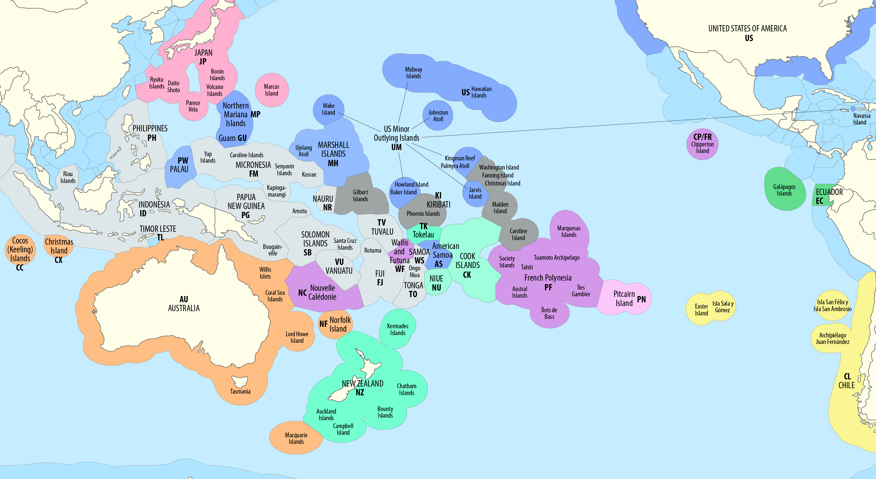
Some countries benefit more than others do from the Law of the Sea. Landlocked countries by definition lack coastline and thus hold neither territorial waters nor EEZ. Countries with long coastlines (USA, Brazil, Canada, Russia) naturally have expansive EEZ. Island countries are defined by their coastlines, thus having corresponding territorial waters and exclusive economic zones. For a small island country, its EEZ may hold much greater surface area and its land does.
In this way, countries of the Pacific Realm have rights to vast ocean territories. Australia’s land area is about 7.7 million square kilometers (3 million square miles), but its basic EEZ is about six million km2. Counting the EEZ of Australia’s small islands adds another two million km2. That eight million km2 exceeds Australia’s land area. (This does not even include Australia’s claim to an EEZ of two million km2 that is adjacent to the Australian Antarctic Territory.) In sum, Australia’s EEZ is the third largest in the world. It is safe to say that every island country of the Pacific Realm claims greater areas of the ocean than they hold land mass. Usually, the ratio of ocean-to-land is large; for instance, for the Solomon Islands, this ratio is 43:1. For New Zealand, the ratio is 14:1. In fact, New Zealand has the world’s ninth largest EEZ at four million km2. Sometimes the ratio is extreme, such as with Nauru measured at 7523:1.
Not all of the Pacific islands are wholly or parts of an independent country. Some islands still have colonial links. Of course, Hawaii is part of the United States. The American territory of the Northern Mariana Islands has an EEZ that is larger than the American EEZ along the Gulf of Mexico. France maintains overseas departments and territories across the globe, including numerous islands in the Pacific Realm. All of these holdings combine to give France the world’s largest exclusive economic zone. Oddly, the EEZ of France in Europe is only 3.3% of the country’s overall EEZ.
Given the prominence of fishing industries throughout the islands of the Pacific, the UNCLOS rights within the exclusive economic zones are financially significant, if not crucial, for the Pacific Realm.
Did You Know?
The exclusive economic zone of the United States is dominated by Alaska. Alaska’s EEZ is 3.77 million km2, which is more than the EEZ of the American mainland (West Coast, East Coast, and Gulf Coast) and the main islands of Hawaii combined. America’s total EEZ is the second largest in the world.
If the expansive exclusive economic zones of distant islands are excluded, as are any claims to Antarctic waters, then the country with the largest EEZ is Russia. Perhaps this is fitting, since Russia has the world’s largest land area too.
The Spratly Islands and the South China Sea around it host numerous jurisdictional disputes, even with UNCLOS.
Cited and additional bibliography:
B1mbo. 2018. “Territorial Waters of the Pacific Ocean.” Wikipedia. https://commons.wikimedia.org/wiki/File:Map_of_the_Territorial_Waters_of_the_Pacific_Ocean.png. Creative Commons Attribution-Share Alike 2.5 Generic.
Migiro, Geoffrey. 2018. “Countries with the Largest Exclusive Economic Zones.” WorldAtlas. June 29, 2018. http://worldatlas.com/articles/countries-with-the-largest-exclusive-economic-zones.html.
Wikipedia Contributors. 2019. “Exclusive Economic Zone.” Wikipedia. Wikimedia Foundation. September 20, 2019. https://en.wikipedia.org/wiki/Exclusive_economic_zone.
