33 North America: Physical Geography I – The Canadian Shield
This chapter was written by an expert on this particular topic – Peter Meserve.
 Many – if not most – regions of continents have a physical basis and in North America, the Canadian Shield exemplifies this. The Shield is a three million square mile (eight million square kilometer) area of ancient geology, directly linked with Canada’s landforms, climates, and cultures. Ringing Hudson Bay, the Shield is the fundamental surface for nearly all of Labrador, Quebec, and Ontario, before extending into parts of Manitoba, Saskatchewan, and the Northwest and Nunavut Territories. These same Precambrian era (beginning 4.5 billion years ago) rocks extend for hundreds of miles under the sedimentary strata of surrounding regions, such as the Great Plains and Central Lowlands.
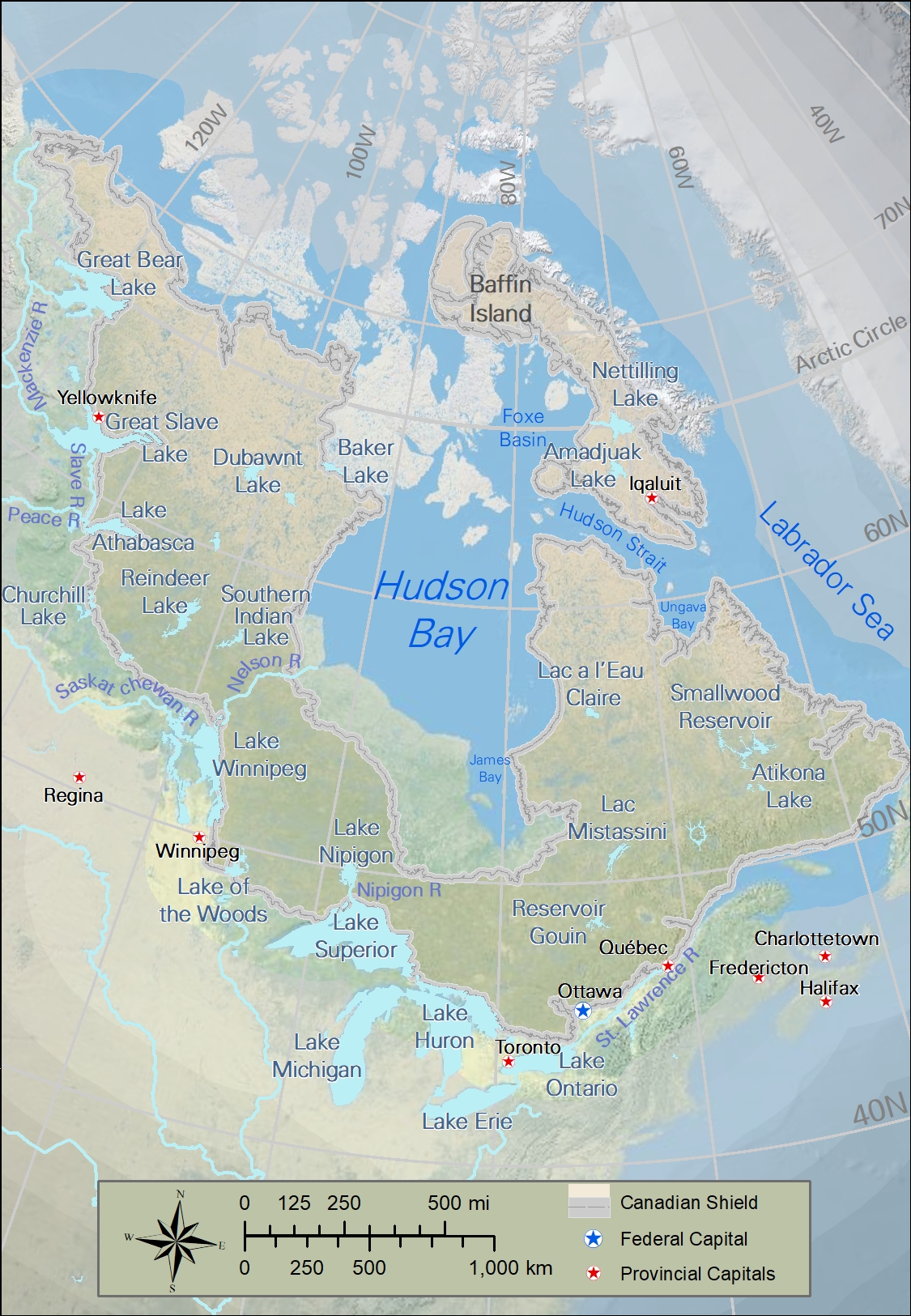
Cartography by Jeff Wandersen.
The Shield’s location – globally and within North America – not only has affected its landforms, but also its climate and therefore its soils and vegetation. In turn, human activities can’t be separated from the Shield’s physical characteristics because resource availability and exploitation, transportation and accessibility, settlement patterns and growth, and even cultures and lifestyles are so strongly affected by this environment.
Most of the rocks exposed in the Shield are over 600 million years old; some are older than four billion years. Their formation during the Precambrian period (sometimes referred to as the Cryptozoic or ‘hidden life’ eon) means that in the Shield there are virtually no fossil fuels (or fossils) but instead it holds an abundance of metal deposits. Native copper (pure copper) was found and used long ago by the indigenous peoples around Lake Superior (especially Michigan’s Upper Peninsula) while more recent mines were critical to the development of both countries. Gold, silver, nickel, and iron deposits have been major economic activities for two centuries; the iron deposits in Minnesota’s Mesabi Range supported the American steel industry from the late 1800s through the 20th century, while Ontario’s Sudbury mines did the same for Canada.
Erosion over millions of years exposed Shield rocks by removing mountains of soil and rock. Not only did this expose the deeper older rocks and allow easier access to mineral resources (including diamonds in recent decades), but also it helps explain the hydrology of the region. First, the rocks of the Shield are mostly igneous (often granitic) and are relatively impermeable. The surface works like a “shield” in blocking water from passing through the rock, snowmelt and rain tend to either runoff downslope (rivers) or be trapped in lower areas as lakes. Second, glacial activity, either through erosion or deposition, has created “deranged” (random) stream patterns and depressions for thousands of lakes. Minnesota may be the “Land of 10,000 Lakes” – check the license plate – but Manitoba is the land of 100,000 lakes! (Canada claims to have the greatest amount of lakes in the world; Finland disagrees.)

The role of lakes and rivers created by glaciers and the Shield has changed over the centuries, but these waterways have always been vital to the inhabitants. During France’s early colonization of Canada, access to the interior was either on foot or by canoe and the French voyageurs were famous for their travels to obtain pelts from the natives (now known in Canada as First Nations). Settlers, especially in Quebec, used the ‘long lot’ system where property included river-frontage for access and then extended onshore. In the last century a “cottage culture” developed where having a summer place on the water was part of the Canadian dream, for the wealthy at first, but then for the middle class. Fishing in Canadian waters now attracts millions of tourists each year and hydropower facilities provide over half of Canada’s electricity.
Winters in the Canadian Shield range from cold (averaging -48°F) around the Great Lakes to extremely cold (averaging -30°F) near the Arctic Ocean, but summers – though short – can be warm to hot. Despite the lakes and rivers, Shield climates are classified as ‘continental’ so that seasonal extremes are the rule. The extreme northern latitudes are a factor. Winter days are extremely short (sometimes nonexistent) and the long summer days (up to 24 hours) allow vegetation to exist at the Arctic, attracting insects and the migrating birds that feed upon them (e.g., Canada Geese and Tundra Swans.) The early fur trade in the Shield relied on the heavier pelts of those animals that live through the brutally cold winters.
True tundra occurs in a climate that is found only on the northern shores of the Shield and lacks the forests that dominate the rest. Since most of the air masses in the Shield lack moisture, there is surprisingly little precipitation (and also little evaporation) but the remaining Shield climates can support pines, firs, and some deciduous trees. In Canada two climates – Taiga and Boreal Forest – dominate the Canadian Shield; taiga forests are shorter, less dense and to the north of boreal forests. The harsh weather of the Shield limits the variety of trees and has resulted in huge expanses of spruces and firs – the best trees for the pulp mills that cover Ontario and Quebec.
Most Shield soils are relatively thin, relatively infertile, and relatively acidic. The glaciers of the last Ice Age removed the existing soils and the development of new soils has been slowed by the climate. In short, agriculture is limited to the few places where rivers or lakes have deposited fertile silt, such as the Clay Belt south of Hudson Bay (where the former Lake Ojibway once stood.) Farther north in the Shield much of the soil is frozen year-round (permafrost), which creates huge problems for construction during summer, melt. In the summer peat bogs (containing decayed vegetation) and swamps appear in the Shield and are a major concern for global warming; the increased decomposition of peat from higher temperatures adds even more carbon dioxide to the atmosphere.
The geology of the Canadian Shield, combined with the history of the rise and fall of the Ice Age and with the northern latitudes of Canada, creates a large swath of Canada that has a plethora of mineral resources exploited for wealth, a network of waterways used for transportation and tourism, and a landscape better suited for forests than for agriculture.
Did You Know?
During the Cold War following WWII, the US was concerned about a nuclear attack by the Soviets (Russians). Since the shortest air route for Soviet bombers to reach America was across the North Pole and Canada, to monitor this potential Soviet threat, a system of radar stations was placed across the Shield. This DEW Line (Distant Early Warning Line) has since been ‘transitioned’ to the North Warning System, but the relative location of the Shield means it remains important to US defense strategies.
Hudson Bay wasn’t a bay before the last Ice Age and eventually in the future it won’t be a bay either. This is due to isostatic rebound, the gradual rise of land after the departure of glaciers or ice sheets.
Cited and additional bibliography:
Leckman, Michael. 2016. Georgian Bay, Canadian Shield. https://tinyurl.com/georgianby. Attribution-NoDerivs 2.0 Generic (CC BY-ND 2.0).
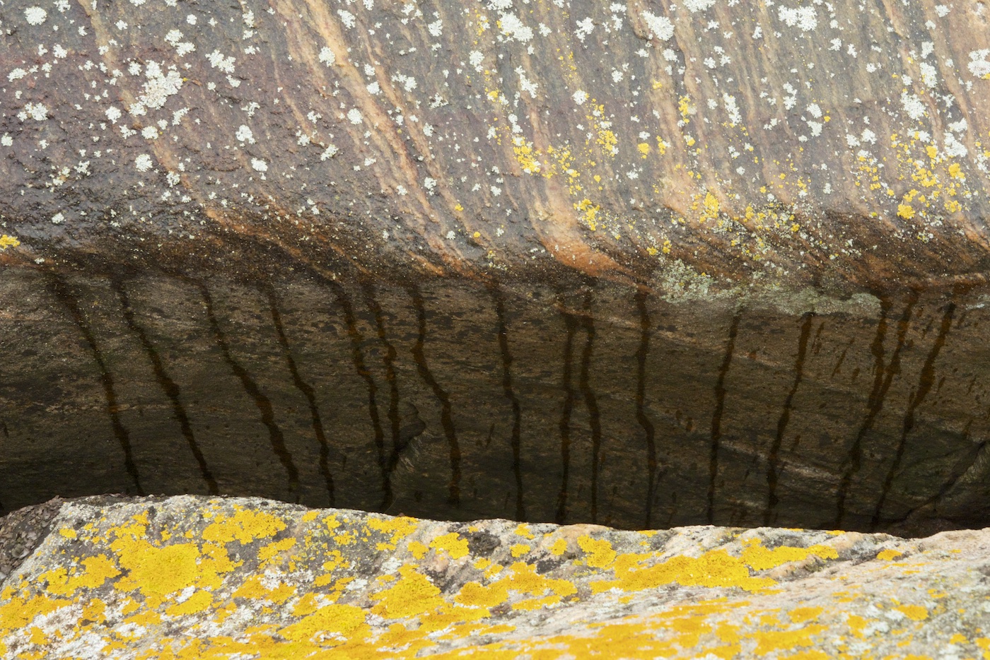
Mariani, Francis. 2016. Drizzle Dripping on the Canadian Shield. https://tinyurl.com/canadianshieldfm. Attribution-NonCommercial-NoDerivs 2.0 Generic (CC BY-NC-ND 2.0).
Wandersen, Jeff. 2020. “The Canadian Shield.” College of DuPage. Instructor Joseph Adduci.
