89 Russian Domain: Physical Geography – Siberian Rivers

Water rolls downhill. We all know that. Rivers flow downward. Of course.
In America, the mighty Mississippi flows southward from Minnesota to Louisiana and into the Gulf of Mexico. Somehow this last fact subconsciously has prompted many Americans to feel intuitively that rivers progress southward. That intuition is incorrect.
In Siberia, most rivers flow downward. Of course. However, in Siberia downward generally is to the north. Three of the four giant rivers of Siberia drain northwards.
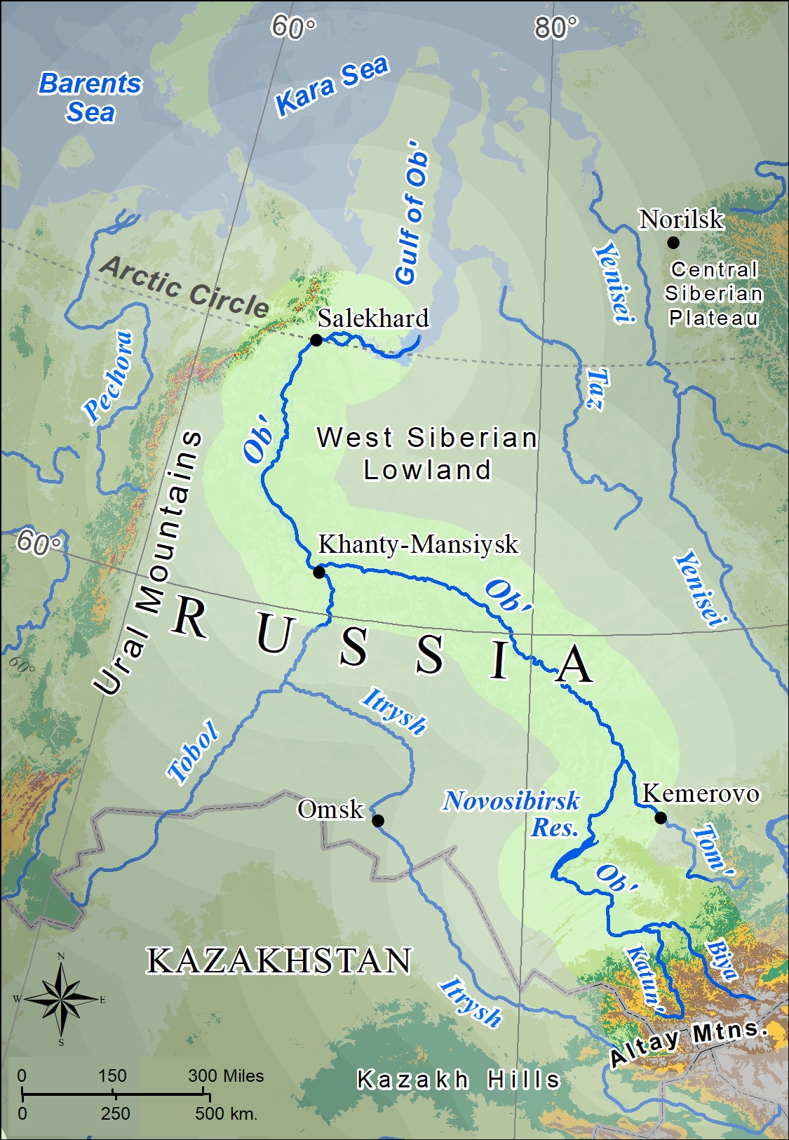
Starting in western Siberia and the Ural Federal District of Russia, there is the Ob’ River. (Note the spelling of the word Ob’ is a feature of the Cyrillic alphabet.) In the Altay Mountains, the smaller streams of the Biya and Katun Rivers begin, later to merge to become the Ob’ River. The significant Irtysh River forms in China also in the Altay Mountains and then roughly parallels the Ob’, usually over 100 miles to the west. When the two rivers join, near the city Khanty-Mansiysk, the surviving name is Ob’. This is a bit curious, given that up to that juncture, the Irtysh River is longer than the Ob’ River. The length of the Ob’ is 2270 miles, but the combined Irtysh-Ob’ River system is measured as the world’s seventh longest. Eventually, the stream widens into Gulf of Ob’ when it reaches the Kara Sea, a portion of the Arctic Ocean. The Gulf of Ob’ is the world’s largest estuary.
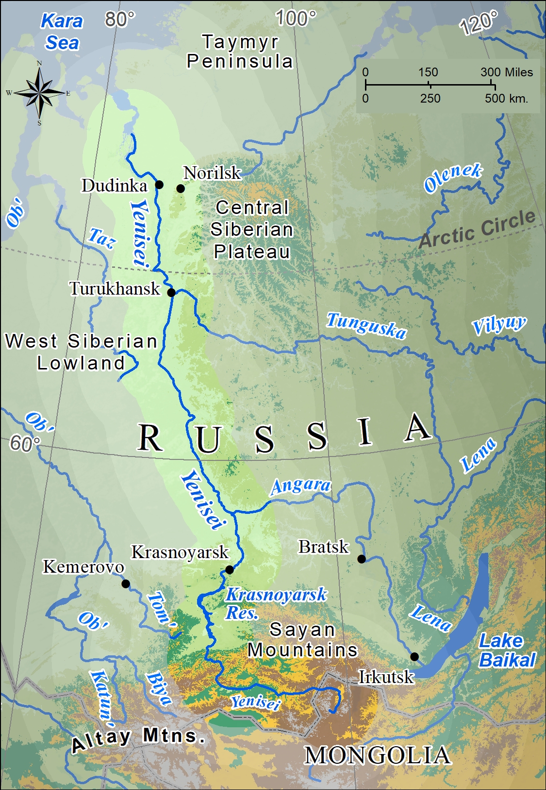
In the Eastern Federal District of Russia, there is the next huge river of Siberia – the Yenisei. The combined Yenisei-Angara system is considered the world’s fifth longest. The source of the Yenisei is in the mountains of northern Mongolia, its major tributary, the Angara River, flows from Lake Baikal.
Both the Ob’ and the Yenisei have major hydroelectric dams built across their southern tracts, respectively in Novosibirsk and Krasnoyarsk. The Novosibirsk Reservoir is Siberia’s largest artificial lake.
In the Far East Federal District of Russia, the Lena River begins in the mountains along the western side of Lake Baikal. The Lena River (Lé na) is the giant stream of Siberia, stretching 2734 miles. Huge on global standards as well, the Lena is the world’s 11thlongest river and draws from the world’s 7thlargest watershed, including from its biggest tributary, the Vilyuy River. Mammoth in a variety of dimensions, the Lena reaches a width of twenty miles across and at the Laptev Sea creates a delta over 250 miles wide. The Lena River and its tributaries are entirely within the borders of Russia, unlike the Ob’ and Yenisei.
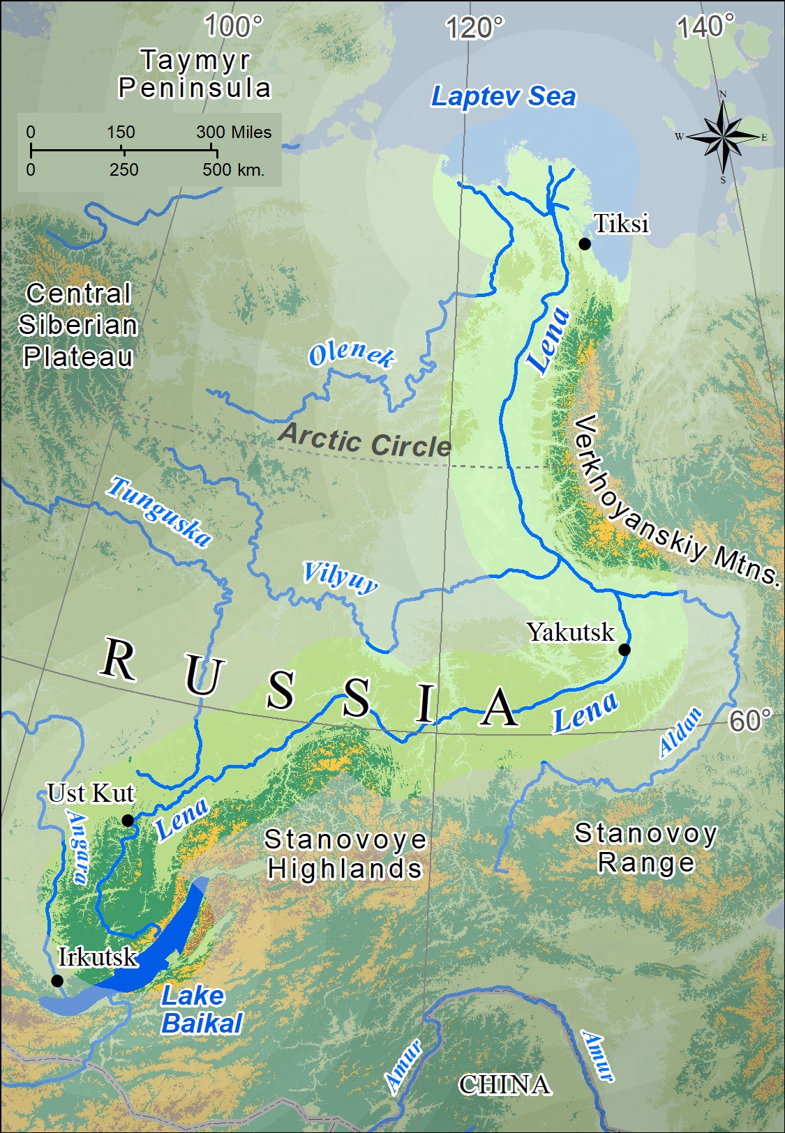
Siberia in general and the region of the Lena River as well is a treasure trove of natural resources and a setting of scarce population distribution. The primary city along the Lena River is Yakutsk with approximately 200,000 people.
During tsarist times in Russia, after Cossack adventurers reached the Lena River in 1623, for many years political and criminal exiles were sent to this region (as well as to many other locations in Siberia and in the Far North). This pattern was followed and expanded during the Soviet period, in particular in the years of Stalin’s rule. In addition, workers were enticed to come to the region to develop the region’s resources (gold, diamonds, even mammoth tusks, and more). Workers were paid double or triple wages and even remote locations were developed with infrastructure, transportation links, and social and cultural subsidies. Now in post-Soviet and oligarchic capitalist Russia, these economic infusions have been eliminated, leaving towns and villages along the Lena to diminish in population but increase in social problems and structural ruin. An ironic consequence is that many in the region feel that communism gave them a better life, in some views even better under the terror of Stalin’s times.

The influx of Russian migrants, by exile or voluntary migration, eventually outnumbered the small populations of native people. The Sakha people, or Yakut as the Russians named them, are the largest group, with Evenk and even the Even making up small shares. For the natives, Russian or Soviet influence and domination brought social change both in terms of urbanization and alcoholism, dramatically reducing original culture and ways of life.
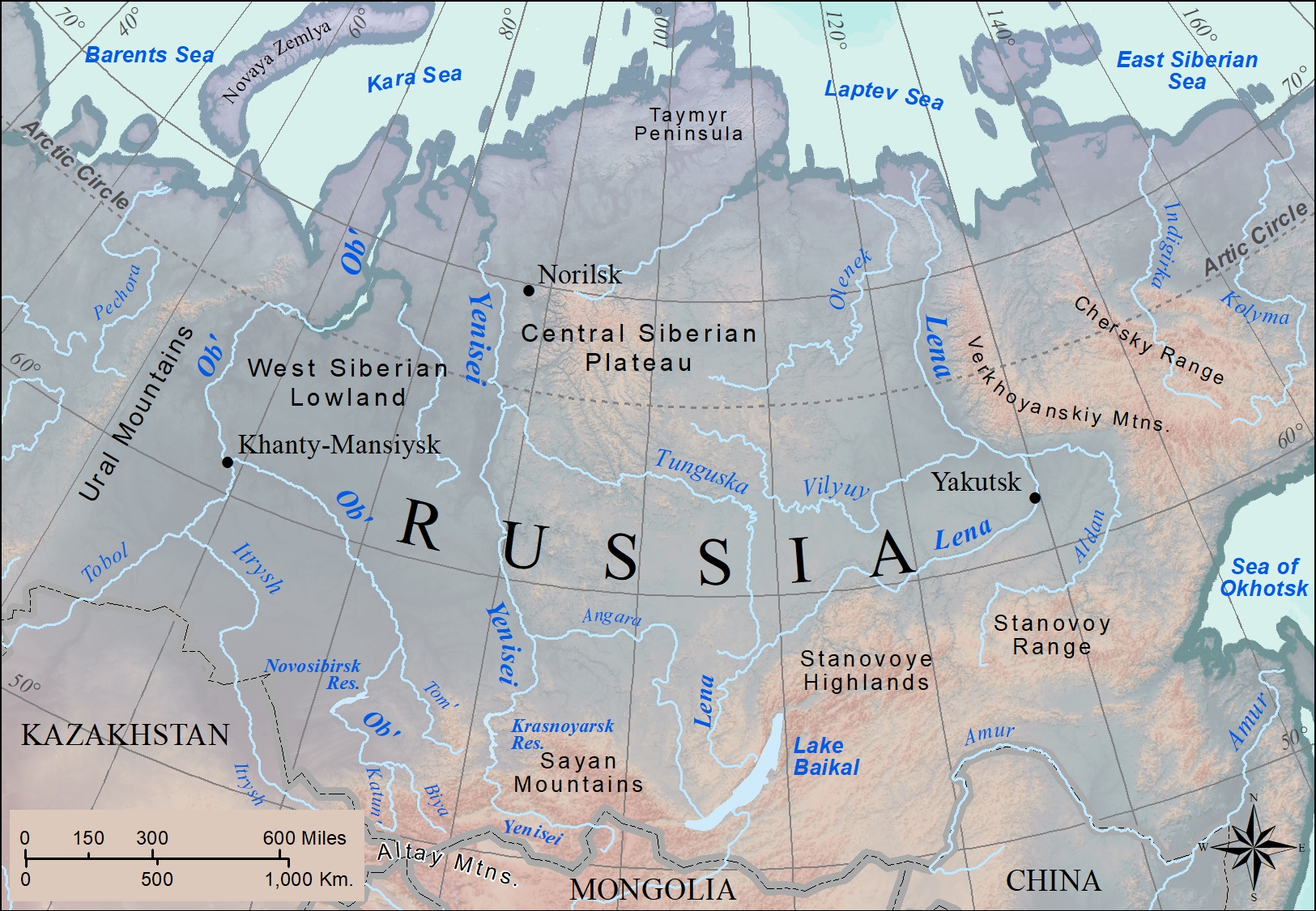
Siberia is the home to a multitude of rivers, from those that sweep vast territories to hundreds of small streams. The overall pattern is that these rivers flow from south to north exiting into any of four major seas (from west to east – Barents, Kara, Laptev, and East Siberian) that are subsets of the Arctic Ocean. Given the legendary cold of Siberia, rivers such as the Lena are frozen for many weeks annually. Naturally, the southern portions of the river thaw first, sending its liquid flowing into the still frozen northern sections. This results in yearly flooding. Abrupt or exaggerated breakup of ice jams caused by this flooding can results in large sections of ice being pushed across land, sometimes devastating towns and villages. Eventually, and again from south to north, the river thaws completely, including the extensive delta which is frozen about seven months of every year. Flooded lowlands become sources of breeding for vast numbers of mosquitoes, horseflies, and other insects. The West Siberian Lowland, the world’s largest section of continuously flat land, is bisected by the Ob’ River and is extensively flooded most every spring.
Did You Know?
The unusual physical and biogeography of the Lena delta has caused it to become a protected area within Russia and to be nominated as a UNESCO Heritage Site.
Pioneer of Soviet communism and the Soviet Union’s first leader, Vladimir Ilych Lenin was born Vladimir Ilych Ulyanov, but took the pseudonym Lenin from the Lena River, drawing inferences from the power and magnitude of the river.
In the Komi language, the word “ob” means “river.”
For 38 photos, often spectacular, of the Yenesei River, its lands, and its peoples, go to: https://www.theatlantic.com/photo/2013/08/a-year-on-the-yenisei-river/100580/
Hot Off the Press
Check Your Understanding
Cited and additional bibliography:
Administrator, NASA Content. 2015. “Siberia’s Lena Delta.” NASA. April 21, 2015. https://www.nasa.gov/topics/earth/earthday/lena_delta.html.
Ducke, Emile. 2020. “Glimpses of the Isolated Communities Along a Remote Siberian River.” The New York Times, September 28, 2020, sec. Travel. https://www.nytimes.com/2020/09/28/travel/russia-ket-river-siberia.html?searchResultPosition=1.
Tayler, Jeffrey. 2013. River of No Reprieve : Descending Siberia’s Waterway of Exile, Death, and Destiny. Boston, Mass: Houghton Mifflin Harcourt.
Taylor, Alan. 2013. “A Year on the Yenisei River – The Atlantic.” Www.Theatlantic.Com. August 23, 2013. https://www.theatlantic.com/photo/2013/08/a-year-on-the-yenisei-river/100580/.
Wiertz, Steve. 2020a. “Siberian Rivers.” College of DuPage GIS class. Instructor Joseph Adduci.
———. 2020b. “Yenesei River.” College of DuPage GIS class. Instructor Joseph Adduci.
———. 2020c. “Lena River.” College of DuPage GIS Class. Instructor Joseph Adduci.
———. 2020d. “Ob’ River.” College of DuPage GIS class. Instructor Joseph Adduci.
