31 N America: Economic Geography I – Geography of the Post-Industrial Era

In Chapter 4, we defined the four sectors of the economy: the primary sector (raw materials extraction), the secondary sector (manufacturing), the tertiary sector (services), and quaternary sector (information). During the preindustrial era, the American economy revolved around the primary sector. In the industrial era, the American economy was focused on the secondary sector. In the current postindustrial era, more and more American livelihoods are dependent on the tertiary and quaternary sectors.
Each era has reshaped the geography of the United States. During the preindustrial phase, the American population was mostly rural, and the country’s geography was highly dependent upon the location of raw materials. In the primary sector, mining has to take place where the minerals are; fishing has to take place where the fish are; timber has to take place where the trees are, and farming is heavily dependent upon the geography of soils and climate. As discussed in Chapter 32, American cities evolved along coasts, lakes, rivers, canals, and railroads in order transport and process those raw materials. Those same cities blossomed during the industrial era, when manufacturers found them to be convenient places to accumulate raw materials and components, and to distribute finished products, as in the Steel Belt.
Here, we will examine the geography of the postindustrial era. How has the rise of employment in the tertiary and quaternary sectors changed the geography of the country?
The Tertiary Sector

The tertiary sector is the service sector, in which workers provide services to businesses and consumers. Examples of the tertiary sector include transportation, retail, wholesale, food service, telecommunications, property maintenance, health care, live entertainment, and public services like police and fire departments, social work, and the military. Because much of the service sector revolves around proximity to potential consumers, the tertiary sector largely reinforced the geography that already existed in the United States – it did little to rearrange it.
One major exception is tourism, which is one of the largest components of the tertiary sector. In the 20th century, as incomes rose in America and around the world, and as modes of transportation became cheaper and faster, more and more people engaged in recreational travel. Some of that travel was to cities that grew up during the industrial era. New York, Chicago, San Francisco, New Orleans, Washington, Boston, and Nashville are all particularly popular destinations, and tourism is integral to the economies of those and other American cities.
Still, there are many towns and cities around the country that grew up almost entirely around the tourism industry. The evolution of places like Las Vegas, Nevada; Orlando, Florida; Sedona, Arizona; Branson, Missouri; Napa, California; and Aspen, Colorado is tied almost entirely to tourism. The same can be said for hundreds of cities and towns along the Atlantic, Gulf, and Pacific coasts, along the upper Great Lakes, in the hills and mountains of the Northeast and the Upland South, in the mountains and canyonlands of the West, and on the islands of Hawaii.
The Quaternary Sector

The quaternary sector deals with generating, managing, and interpreting information. Finance, media, technology, education, consulting, engineering, and research are just a few examples of this sector. It is the fastest-growing sector of the American economy, and is emerging as a leading employer for college-educated Americans. The quaternary sector enjoys much more geographic freedom than the other three economic sectors. This information sector is essentially a “weightless” economy. Theoretically, information sector jobs can be performed just about anywhere. If you’re designing software, or analyzing risk for an insurance firm, you don’t rely on raw materials or transportation. Still, there is some geography to the quaternary sector. The quaternary sector has thrived in four kinds of places: large metropolitan areas, places near large university complexes, in places with specialized labor pools, and in places with attractive topography and climates.
Like the secondary sector, the quaternary sector tends to favor large metropolitan areas. Workers in this sector are often highly educated, and different firms will actively compete with one another for the most talented employees. Large metropolitan areas offer more amenities to potential employees, meaning that they offer more interesting stuff to do. If two firms are competing for the same employee, and one firm is located in New York City, and the other is located in Wichita, the firm in New York is likely to win that battle. Also, large cities have a bigger pool of potential employees, which makes labor cheaper.
The quaternary sector is also thriving near large university complexes – places that have several prestigious colleges or universities. Such places offer a larger pool of college graduates to recruit from. Also, universities are the epicenter of cutting-edge research, and quaternary sector firms often consult and partner with these universities, so being in close proximity to them is beneficial. Universities are to the Information Age what coals mines were to the Industrial Revolution.
A prime example of this is Silicon Valley, just south of San Francisco. Its proper name is the Santa Clara Valley, and it falls right between Stanford University and Cal-Berkeley, two global leaders in software design and research. Route 128 is another example. A globally prominent research corridor, Route 128 is located in Boston, the home of Harvard, MIT, and many other leading colleges and universities. Chicago is yet another example. Unlike many other Midwestern industrial cities, Chicago has made a smoother transition to the post-industrial era, largely because it is bookended by Northwestern University and the University of Chicago, two of the most prestigious research universities in the country.
 This economic importance of colleges and universities can be found throughout the country. If you examine any state, and ask which city is doing the best economically, it’s often home to a flagship university. Ohio and Michigan, for example, are two states that have suffered from significant industrial decline. Still, places like Columbus (home of Ohio State), East Lansing (Michigan State), and Ann Arbor (Michigan), have fared pretty well because of their universities.
Additionally, highly specialized fields within the quaternary sector are often already concentrated in a particular city. Those wishing to work in that field are wise to move to that city, and firms in the field are practically required to locate there if they want to find employees. Examples include advertising in New York, auto engineering in Detroit, software development in Boston and San Francisco, food research and marketing in Chicago, and different segments of the entertainment industry in New York, Los Angeles, Chicago, Nashville, and Austin.
Finally, and somewhat ironically, environment has played a major role in the quaternary sector’s reshaping of American geography. It is ironic because the information sector is largely divorced from environmental needs. But just as large cities can lure potential employees, so can attractive environments. This is known as amenity migration – migration driven by preferences for certain kinds of natural environments. Often, amenity migration is driven by topography – a lot of Americans prefer mountainous environments and the recreational opportunities that go along with them. This explains the recent population boom in states like Colorado and Utah. But the far more important factor has been climate. Given the choice, more Americans prefer to live in places with mild winters. A college graduate who is offered one job in Buffalo, and another in San Diego, is far more likely to choose the job in San Diego.
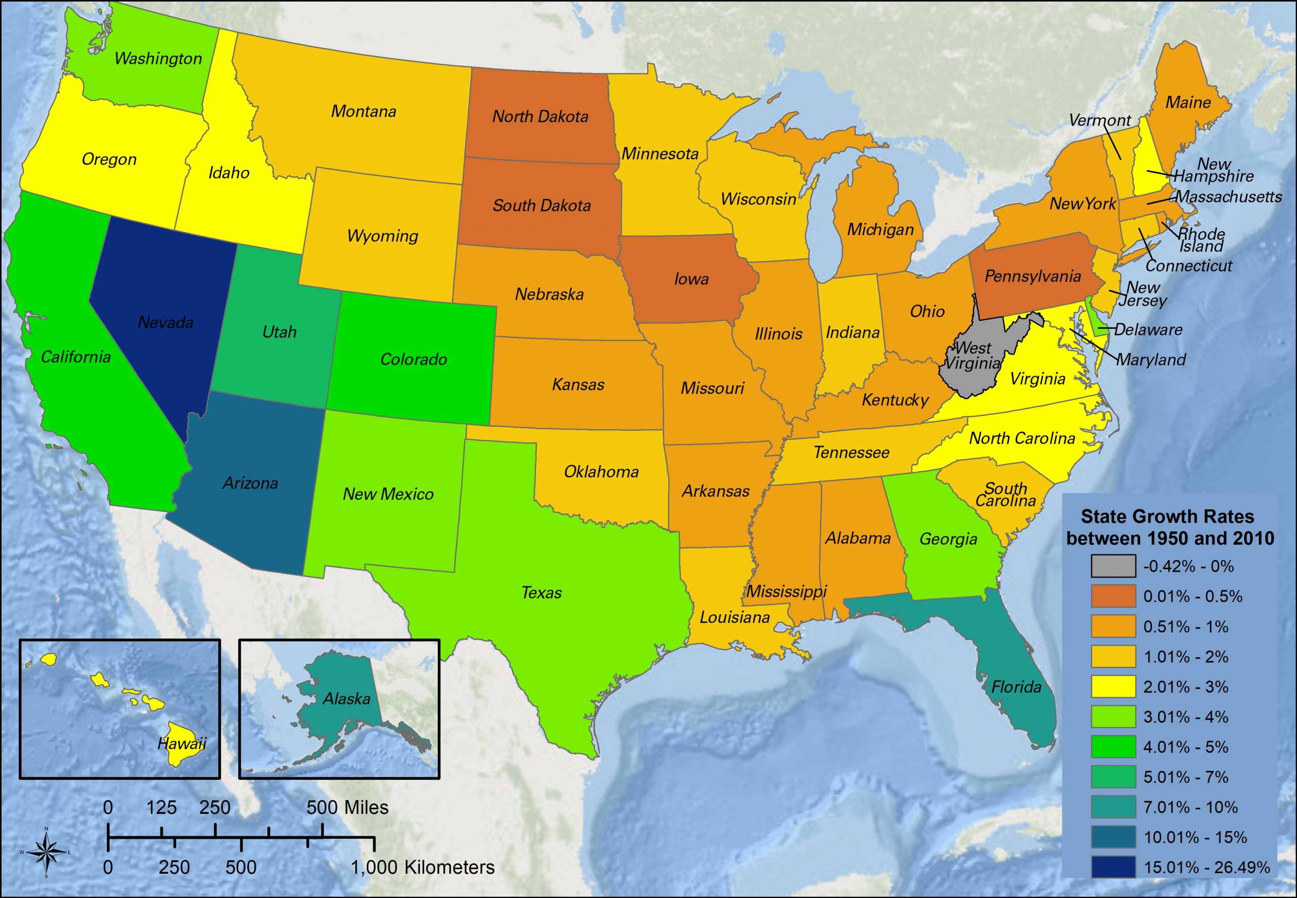
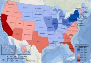
This subset of amenity migration is known as Sunbelt migration. Definitions of the Sunbelt vary, but it is most often associated with states in the American South, Southwest, and West Coast. California, Texas, Georgia, Florida, Nevada, and Arizona best exemplify the Sunbelt. Sunbelt migration accelerated in the 1950s with the evolution of the quaternary sector, and shows few signs of slowing down. The effects of Sunbelt migration can be seen in the table below, which shows the twenty largest American metropolitan areas in 1950, and again in 2010:
Selected American Cities, ranked by population
| Rank | 1950 | 2010 |
|---|---|---|
| 1 | New York | New York |
| 2 | Chicago | Los Angeles |
| 3 | Los Angeles | Chicago |
| 4 | Philadelphia | Dallas-Ft. Worth |
| 5 | Detroit | Houston |
| 6 | Boston | Washington |
| 7 | San Francisco-Oakland | Miami |
| 8 | Pittsburgh | Philadelphia |
| 9 | St. Louis | Atlanta |
| 10 | Washington | Phoenix |
| 11 | Cleveland | Boston |
| 12 | Baltimore | San Francisco-Oakland |
| 13 | Minneapolis-St. Paul | Riverside |
| 14 | Buffalo | Detroit |
| 15 | Cincinnati | Seattle |
| 16 | Milwaukee | Minneapolis-St. Paul |
| 17 | Kansas City | San Diego |
| 18 | Houston | Tampa |
| 19 | Providence | Denver |
| 20 | Seattle | St. Louis |
Over that sixty-year period, New York retained its spot at the top of the list, but the rest of the list has been rearranged by Sunbelt migration. Fourteen cold-winter metro areas saw their population ranks decline, including Chicago, Philadelphia, Detroit, Boston, St. Louis, and Minneapolis-St. Paul, Pittsburgh, Cleveland, Baltimore, Buffalo, Cincinnati, Milwaukee, Kansas City, and Providence. Eleven mild-winter metro areas – Los Angeles, Houston, Seattle, Dallas-Ft. Worth, Miami, Atlanta, Phoenix, Riverside, San Diego, and Tampa – saw their rankings improve.
Did You Know?
Cited and additional bibliography:
Wandersen, Jeff. 2020a. “Change in State Share of National Population, 1950-2010.” College of DuPage. College of DuPage GIS class. Instructor Joseph Adduci.
———. 2020b. “State Growth Rates, 1950-2010.” College of DuPage GIS class. Instructor Joseph Adduci.
