79 Latin America and the Caribbean (LACAR): Political Geography II – Puerto Rico (A Shaken Island)
“You want a lesson? I’ll give you a lesson. How about a geography lesson? My father’s from Puerto Rico. My mother’s from El Salvador. And neither one of those is Mexico.”
– Jennifer Esposito, American actress
This chapter was written by an expert on and resident of Puerto Rico – Professor Christian Goergen.

The Commonwealth of Puerto Rico is located in the northeast Caribbean Sea, about 1000 miles southeast of Miami. With a total area of 5320 square miles, it is the smallest of the Greater Antilles islands, just about 100 miles long and 50 miles wide. While the 3.2 million inhabitants of Puerto Rico are U.S. citizens, Puerto Rico is not a U.S. state but is considered an associated or unincorporated territory to the U.S. The U.S. Congress holds the ultimate power over Puerto Rico but Puerto Ricans cannot vote in U.S. elections and the UN Special Committee on Decolonization has frequently called on the U.S. government to initiate a process “that would allow Puerto Ricans to fully exercise their inalienable right to self-determination and independence.”1
While the Puerto Rican standard of living is among the highest in Latin America, the island has struggled for many years with economic decline and rising debt. In 2016 this came to a head and the U.S. Congress passed into law the Puerto Rico Oversight, Management, and Economic Stability Act or PROMESA.2 The law tries to address the debt by establishing an oversight board and a process for restructuring the debt but also has the power to approve infrastructure projects. Known in Puerto Rico as “la junta de control fiscal” the board was very unpopular from the start as another reminder of Puerto Rico’s quasi-colonial status.
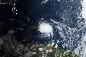
Just when the opposition to PROMESA gained strength, an even more devastating natural event hit the island. On Wednesday, September 20th, 2017, the category 5 hurricane Maria struck the southern side of Puerto Rico and crossed the entire island, leaving behind massive devastation. While the original death toll was reported as 64, later studies found that close to 3,000 people lost their lives as a result of Maria. Tens of thousands lost their home, while the entire island was without fresh water and electricity for weeks and sometimes months. Water, food, medicine and fuel were all in very short supply. Over 100,000 people left the island for good to resettle elsewhere. The total damage to the island has been estimated to be close to $100 billion. Thus, Maria was the deadliest natural disaster in U.S. history.
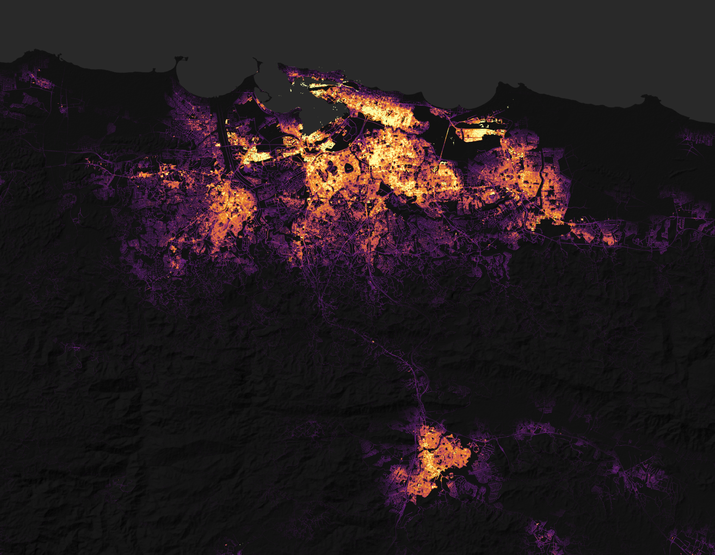
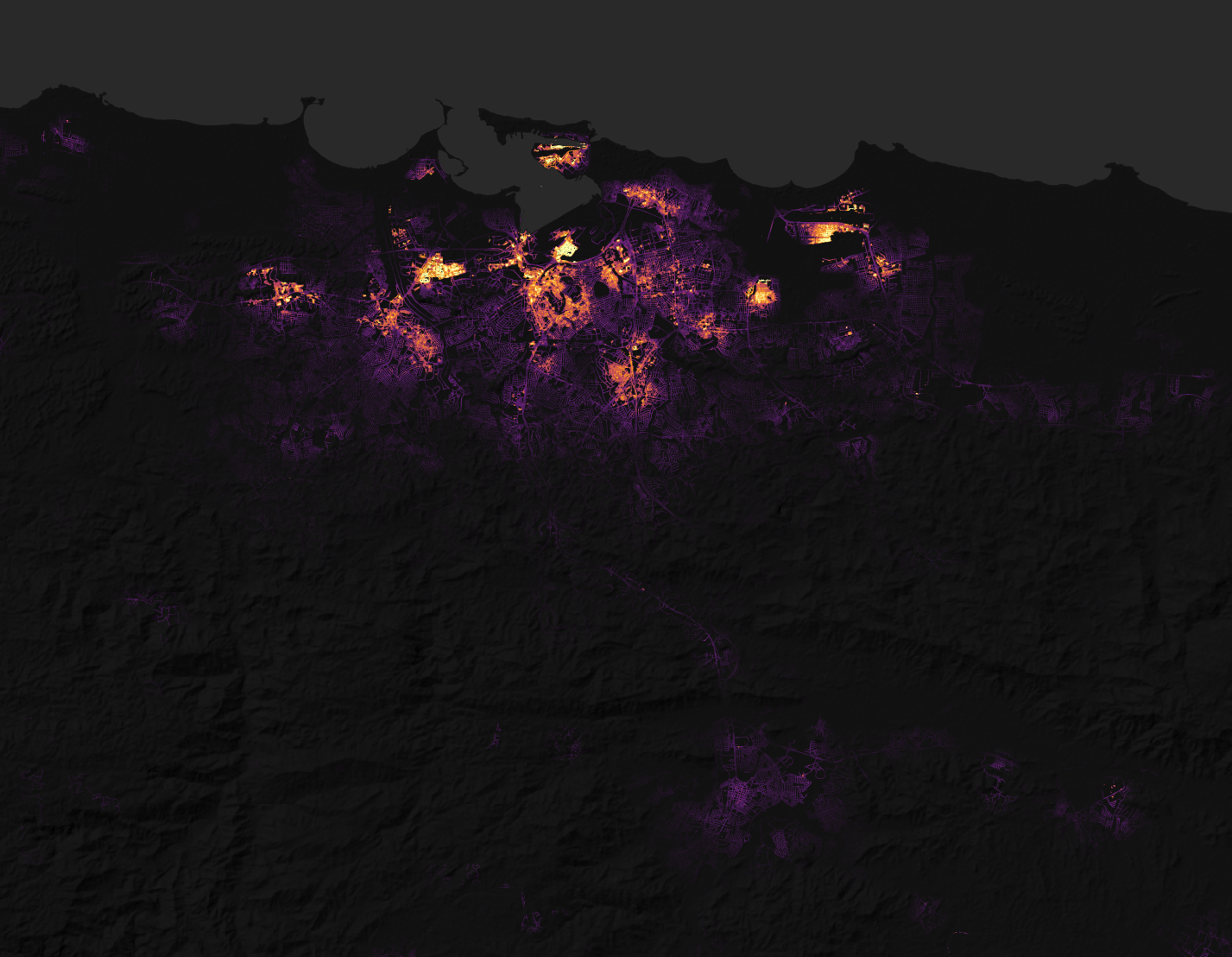
The above images are from the NASA Earth Observatory. On the left is a view of the light pattern of a night at San Juan, Puerto Rico. On the right is the same location, but as a composite of the nights of September 27-28, 2017, after Hurricane Maria struck the island.
In 2019, after two years of intense efforts of rebuilding the infrastructure, life on the island was slowly returning to a resemblance of normal when a new wave of political and natural disturbances hit Puerto Rico. In July, a series of text messages between Governor Ricardo Rosselló, members of his cabinet, and lobbyists became public. In those chats, the men were mocking women and victims of hurricane Maria using crass and vulgar language. In addition, a scandal erupted, accusing Rosselló and others of a multi-billion-dollar corruption scheme. Massive street protests ensued, calling for Rosselló’s removal. By some estimates close to 500,000 people gathered in San Juan, for one of the largest protests in the island’s history. Rosselló resigned on August 2nd, 2019.3
Based on the Puerto Rican Constitution, the person in line to take over if a governor dies or resigns is the secretary of state. Shortly before stepping down, Rosselló had appointed a congressional representative Pedro Pierluisi, a close ally, to that post and he was indeed sworn in on August 2nd. However, cries of foul play emerged immediately. The president of the Senate, Thomas Rivera Schatz, filed a challenge with the Supreme Court of Puerto Rico, arguing that Pierluisi’s appointment was invalid, since he had only been approved by the House but not the Senate. The Supreme Court concurred and Pierluisi was removed from office on August 7th and replaced by the Minister of Justice, Wanda Vazquez. Vazquez, who at first was reluctant to take the position, was constitutionally next in line, since the secretary of state position was vacant. Thus, Puerto Rico has the dubious distinction of having three different governors within one week.
While the new governor was struggling to clean up the mess left behind by the previous administration, nature created a new shock for Puerto Rico – literally. At 2:24 am local time on January 7th, 2020, a magnitude 6.4 earthquake hit the southwest region of Puerto Rico. In the cities of Ponce and Guanica, thousands of people ran into the streets searching for safety. This was the strongest earthquake to hit Puerto Rico in over 100 years and the government declared a state of emergency. Small shocks had started to occur in December and continued in the aftermath of the 6.4 quake. Around 800 buildings were damaged and approximately 8000 people were displaced. For weeks entire families were sleeping in the streets and in public parks due to their fear of another big quake. The quakes also led to an outpouring of support by people around the island who delivered supplies and support for the local population. Between December 2019 and June 2020 close to 10,000 earthquakes have been registered in and around Puerto Rico, mostly on the south side. Most of them are minor quakes between 2.0 and 3.0 on the Richter scale. So why all this shaking? The U.S. Geological Survey explains that Puerto Rico is located between the North American and the Caribbean tectonic plates which has an active plate boundary. In addition, Puerto Rico is surrounded by deep ocean trenches including the Puerto Rico trench with a depth of 8,400 meters (27,000 ft).4
The first cases of COVID-19 – two Italian tourists – were confirmed in Puerto Rico on March 13th, 2010. However, the new governor Wanda Vazquez had acted pre-emptively and created a COVID-19 task force at the end of February to deal with the emerging threat. She declared a state of emergency on March 12th– with zero local cases – and enacted strict rules to stop the spread of the virus. The whole island was under curfew from 7:00 pm to 5:00 am. All businesses were closed except for pharmacies, gas stations and grocery stores. No one was to leave the house except for emergencies and food shopping. No social gatherings of any kind were permitted. Businesses who violated the rules faced a fine of $5000 or 6 months in jail. Even the beaches were off limits.
Governor Vasquez supposedly modeled her response after that of Singapore, another island nation. However, Puerto Rico did not benefit much from its island status since there was a steady stream of expatriates returning to San Juan airport, many of them from Corona hotspots New York and Miami. In addition, cruise ships had delivered the first cases of COVID-19 to Puerto Rico. While the government was able to stop the docking of cruise ships early on, it took Vazquez until April 8th to request that the FAA (Federal Aviation Agency) stop flights from U.S. hotspots. The number of flights was reduced, but it never came to a full stop and it is safe to assume that Puerto Rico received most of its initial cases from the outside. Overall, Puerto Rico’s strict – some would say draconian – measures have been successful. At the beginning of June, the total number of affected people is still below 5000 and the number of deaths stands at 142. That constitutes a rate of about 45 death per million in Puerto Rico, compared to about 300 death per million in the U.S.
The 12-month period from June 2019 to June 2020 has been one of the most challenging this small island has had to face. However, political turmoil, natural disaster and pandemic did not bring Puerto Rico to its knees. It is a tribute to the resilience and resourcefulness of Puerto Ricans that this continues to be “La Isla del Encanto” – the island of enchantment.
Did You Know?
Hot Off the Press
Cited and additional bibliography:
1 “UN Decolonization Committee Approves Text Calling upon US to Expedite Self-Determination for Puerto Rico.” 2016. Caribbean Business. June 21, 2016. https://caribbeanbusiness.com/un-decolonization-committee-approves-text-calling-upon-us-to-expedite-self-determination-for-puerto-rico/.
2 Wicker, Roger. 2016. PROMESA. Vol. S. 2328. 114th Congress.
3 Ortiz, Jorge. 2019. “Puerto Rico Had Three Governors in a Week. Now What?” USA Today, August.
4 Marshall, Miri. 2020. “Why Are so Many Earthquakes Shaking Puerto Rico?” Wusa9.Com. January 12, 2020. https://www.wusa9.com/article/weather/weather-blog/puerto-rico-still-shaking-why-so-many-earthquakes-strike-the-area/65-e52d8485-ed61-438e-bbcb-f124d808dba7.
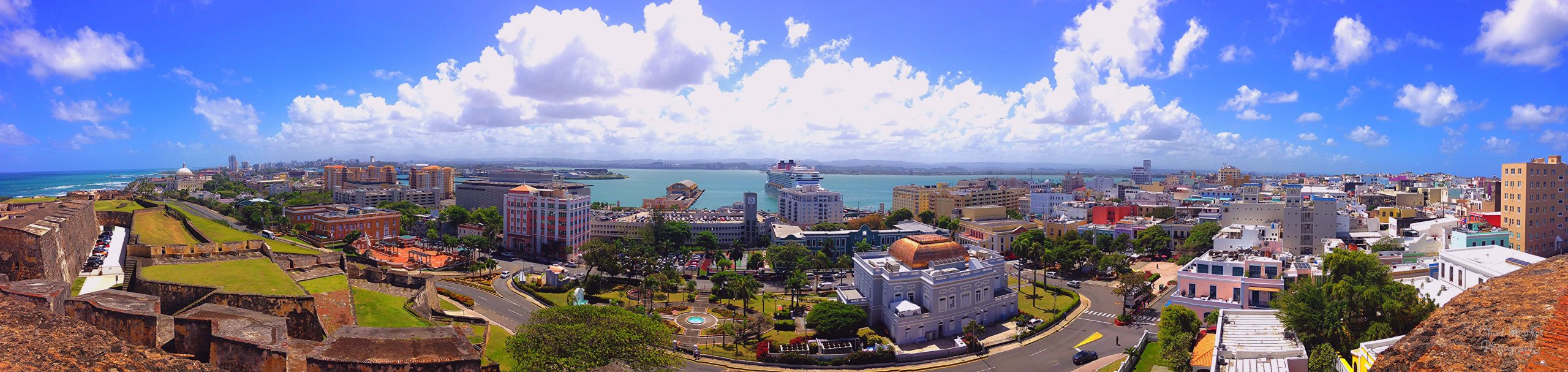
Sparkes, Chad. 2015. San Juan, Puerto Rico. https://tinyurl.com/sanjuanpuerto. Attribution 2.0 Generic (CC BY 2.0).
Stevens, Joshua. n.d. Hurricane Maria Lashes Puerto Rico. Accessed June 9, 2020a. https://earthobservatory.nasa.gov/images/91004/hurricane-maria-lashes-puerto-rico. NASA Earth Observatory.
———. n.d. Pinpointing Where the Lights Went Out in Puerto Rico. Accessed June 9, 2020b. https://earthobservatory.nasa.gov/images/91044/pinpointing-where-the-lights-went-out-in-puerto-rico. NASA Earth Observatory.
