60 Europe: Physical Geography II – Iceland
“From the mountain and burn, the path of our time. Hail people of Iceland, Journey of a land anew.”
– From the song “Iceland” on the album “Leviathan” by the heavy metal band Mastodon.

Iceland is a small island country, situated in the North Atlantic Ocean, west of Norway and east of Greenland. The name of the country is suggestive of ice, obviously. Indeed, over 10% of the surface is glacier. However, the island was created and still is being built by volcanic eruptions, so “ice” doesn’t tell the whole story.
The story or tale of its naming goes back to the arrival of Flóki Vilgerðarsonin about the year 870. Flóki was greatly disappointed in the harshness and travails of that year’s frigid winter, so he spitefully named the place Iceland.
The popular series of books collectively titled “A Song of Ice and Fire” found great success as the TV series “Game of Thrones.” Iceland has long been called “land of fire and ice.” Appropriately, some of the scenes in “Game of Thrones” were filmed in Iceland.
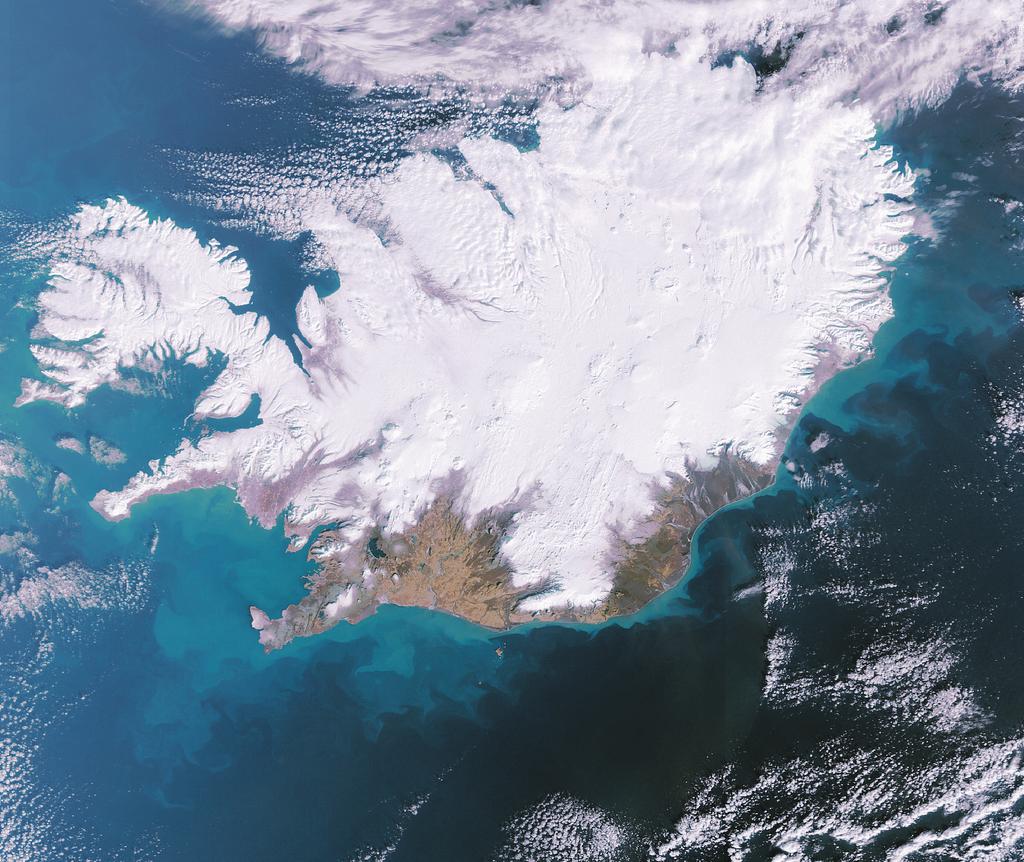
Indeed, the complicated physical geography of Iceland is a mixture of fire and ice. Iceland’s geographic location as an island almost reaching the Arctic Circle certainly produces cold weather. The main island of Iceland sits barely south of the line of 66.5° north latitude, while some smaller islands of the country do extend above that line. Truly, in winter Iceland can be quite snowy, as seen in the satellite photo to the left.
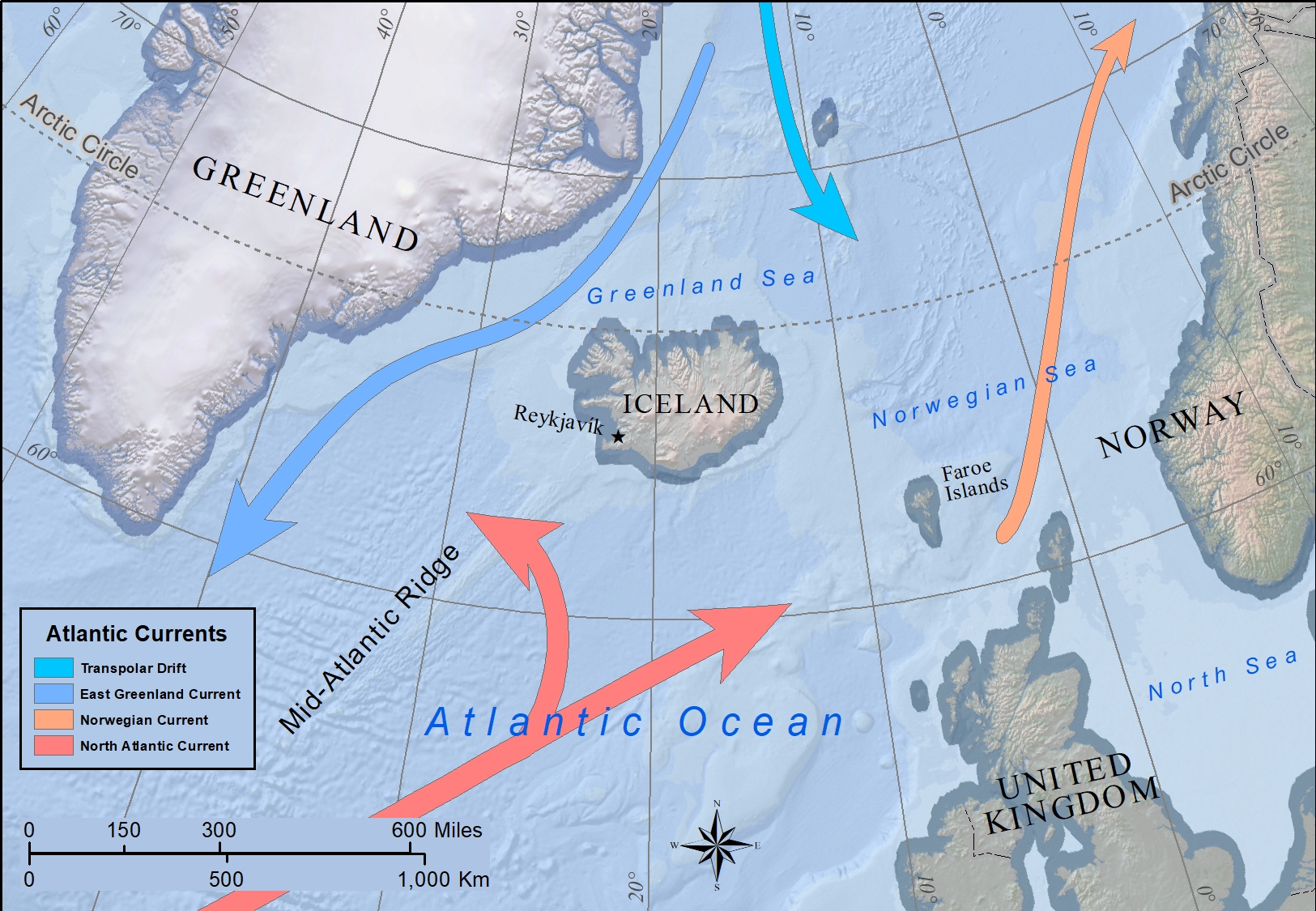
However, the North Atlantic Current (or Drift), as an extension of the warm Gulf Stream, brings temperate Atlantic waters to the coastlines of Iceland. In this way Iceland isn’t as icy as it otherwise would be.
Clearly icy at times and in places, it is Iceland’s volcanic nature that belies the icy name. Iceland sits astride the Mid-Atlantic Ridge that stretches the length of the Atlantic Ocean, north to south. In the North Atlantic, the ridge marks the meeting of the edges of the North American and Eurasian tectonic plates. These volatile edges produce dramatic geologic changes; in this case, as a divergent plate boundary. As these tectonic plates slowly move apart, molten rock material is released between them. Throughout the Atlantic Ocean this process has built numerous seamounts, rock formations that would be hills, mountains, and volcanoes if on land. Seamounts, however, do not reach the surface of the ocean.
Apparently, Iceland is different than these seamounts. In fact, Iceland adds a second geologic process to its development. The generally understand process of hot spot or mantle plume occurs where a weak spot in the Earth’s mantle releases molten material. The process illustrates the building blocks of the Hawaiian Islands. When under oceans, these long-lasting hot regions contribute such large quantities of molten material that islands are formed, in contrast to the sub-surface seamounts.
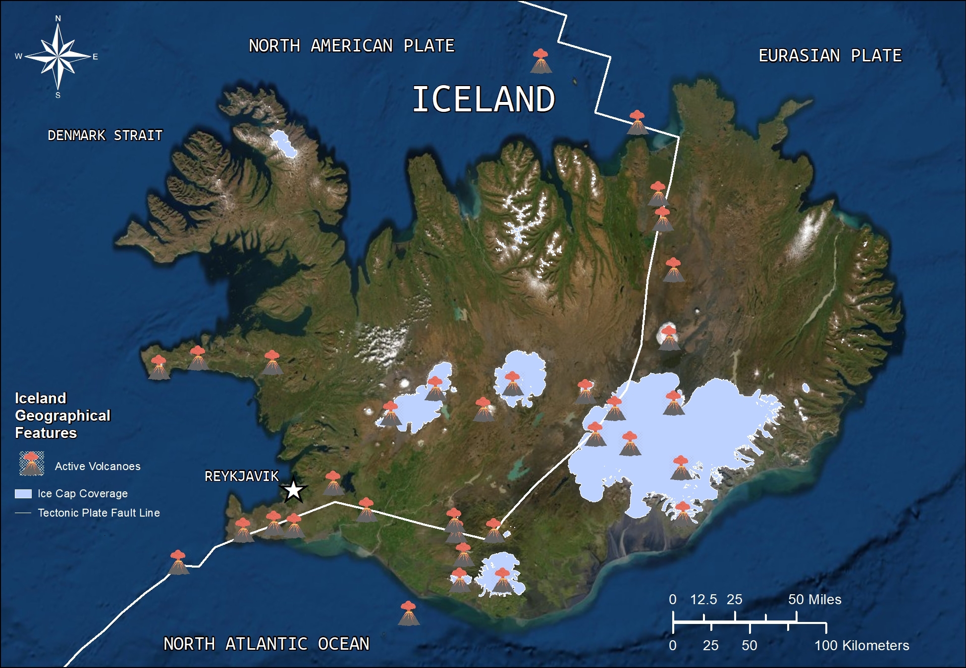
Place Iceland on the Mid-Atlantic Ridge to start the creation of seamounts at that location. Add a hot spot to the same location to enhance by substantial amounts that quantity of molten rock, thereby building a fine volcanic island in the North Atlantic Ocean. It is noteworthy that the Hawaiian Islands combine the movement of continental drift over a hot spot that over a few million recent years has switched on and off. Thus, the fixed hot spot has produced several Hawaiian Islands as continental drift has moved them along. In contrast, apparently due to the conditions of the Mid-Atlantic Ridge, Iceland has remained in a fixed location even as the ocean floor spreads apart. For instance, note that the Faroe Islands to the east have moved progressively in that direction.

Along with volcanoes, Iceland has several other geothermal landscape features. The most famous thermal site, the Blue Lagoon, actually is a manmade pool created from water out of the adjacent geothermal heating plant. The country’s five geothermal heating plants produce about ¼ of the island’s electricity. Furthermore, these plants contribute heating and hot water for about 7/8thof the country’s needs.
The term geyser is derived from the Icelandic word geysir. Hot springs, geysers, and mud pools are found in Iceland. Overall though, volcanoes are the big dynamic features of this country. There are about 130 volcanoes on the island with several being active still. Eighteen volcanoes there have erupted since the year 871. Lakagigar erupted in 1873 causing devastation and killing 10,000 people. Eyjafjallajökull blasted in 2010, sending so much ash into the atmosphere that air travel through the region was canceled for several weeks.
And yet, Iceland has glaciers. In fact, its largest glacier or ice cap is Vatnajokull, the area of which is three times the size of Rhode Island. The island has 269 named glaciers. It does snow in Iceland. Glaciers are formed by large amounts of snow, compressing into ice over long periods of time. In February 2017, the capital city Reykjavik took in twenty inches of snow, a record for that month. Generally, more snow occurs in the northern regions of the island and in higher altitudes. Some areas, often including Reykjavik, receive only modest snowfalls. However, over the centuries snowfall and cold weather did allow the creation of numerous glaciers.
Add a volcanic eruption to a glacier and you may get a jökulhlaup, an abrupt torrent of water like a river that moves with great speed and force. When a volcano has been capped by a glacier, but returns to activity, an eruption will suddenly melt the glacier, releasing vast amounts of water to flow downhill.
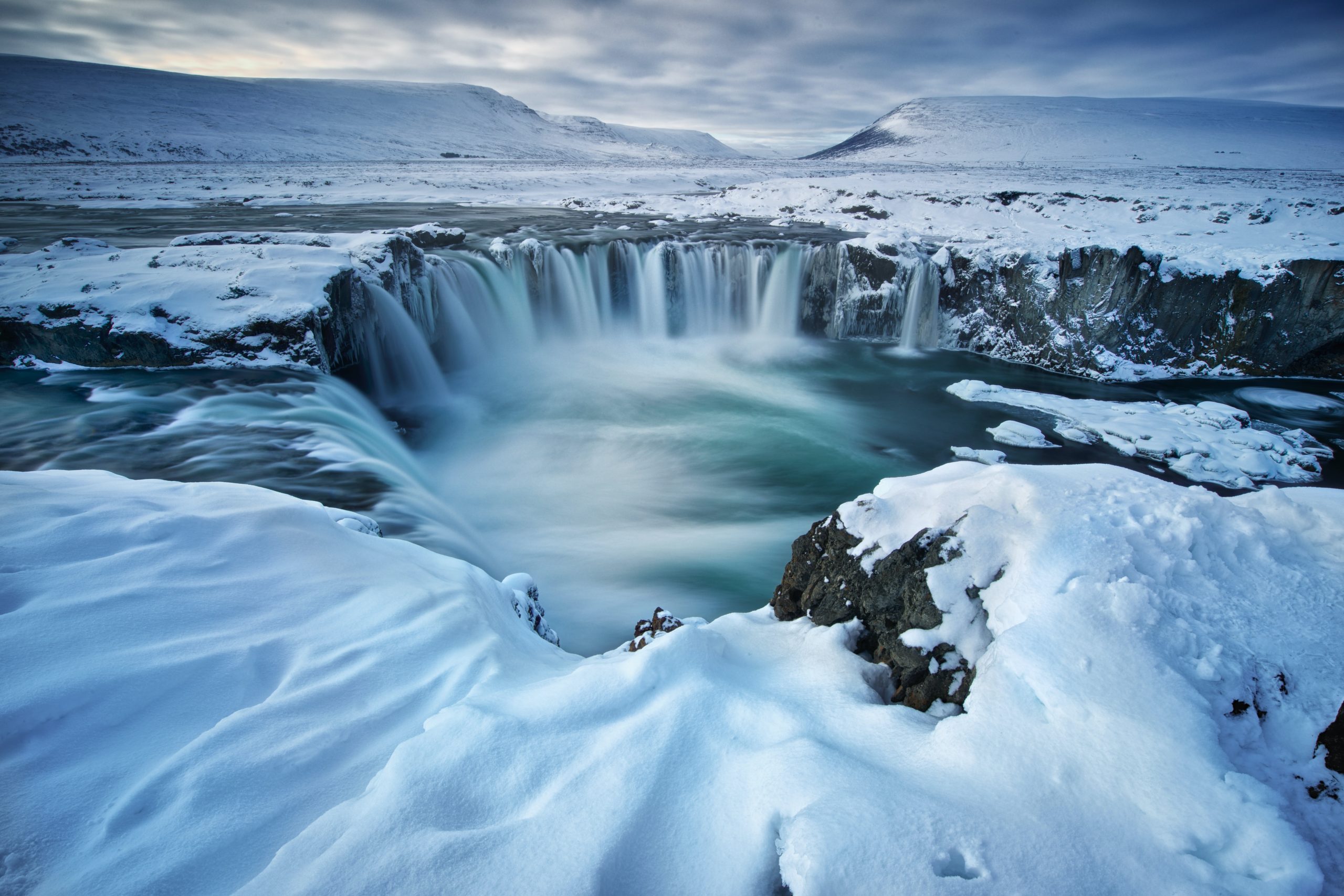
Glaciers and flowing water have created waterfalls in Iceland, such as Goðafoss, seen in this photo. Click below for a brief look at Skogafoss, noting the dark volcanic rock. Do you now realize that foss means waterfall in Icelandic?
Not impressed enough yet? Check out this jagged landscape and yet another foss. Video by Svanur Gabriele via Pexels.
Direct Link to Foss Video (New Tab)
So, should Iceland be named as it is? Sort of. Maybe the author George R. R. Martin came closer with the phrase “ice and fire.” Or fire and ice. Just so it’s not named Greenland, for there is very little green in Iceland. But then Greenland, that’s another story.
Did You Know?
Sometimes architecture is influenced by the physical landscape. For this type of example in Iceland, watch this short video.
Direct Link to Harpa Concert Hall Video (New Tab)
For an interesting explanation of the creation of maps for the “Game of Thrones” series,
go to: https://www.geoawesomeness.com/maps-games-thrones-created/
Both Star Trek and Star Wars films have used locations in Iceland for filming.
Check Your Understanding
Cited and additional bibliography:
Gabriele, Svanur. 2020. “Iceland.” https://www.pexels.com/video/5453159/.
“Hotspots [This Dynamic Earth, USGS].” 2019. Usgs.Gov. 2019. https://pubs.usgs.gov/gip/dynamic/hotspots.html.
Monnier, Christine. 2020. “Harpa Concert Hall.” College of DuPage – Field and Experiential Learning / Study Abroad and Global Education. 2020. https://cod.yuja.com/V/Video?v=1954873&node=7531879&a=1408815644&autoplay=1.
Petry, Richard. 2007. Iceland. https://www.flickr.com/photos/themapaddict/6079221099/in/album-72157627515633350/. Attribution-NonCommercial-NoDerivs 2.0 Generic (CC BY-NC-ND 2.0).
Scroggs, Ian. 2020. “Iceland.” College of DuPage GIS class. Instructor Joseph Adduci.
Videvo. n.d. “Double Rainbow at Waterfall Base.” Accessed July 20, 2020. https://www.videvo.net/video/double-rainbow-at-waterfall-base/452800/.
Wiertz, Steve. 2020. “Iceland Region.” College of DuPage GIS class. Instructor Joseph Adduci.
