17 Pacific Realm: Political Geography I – Why is Hawaii in Polynesia?
 Regional geography studies the people and places of a cohesive region. A region is defined to be an area with multiple shared characteristics over a range of categories, including both physical and human geographic characteristics. The secret of creating a region, which is a human construct not a naturally begotten unit, is to cluster together as many similarities as possible, while excluding geographic differences.
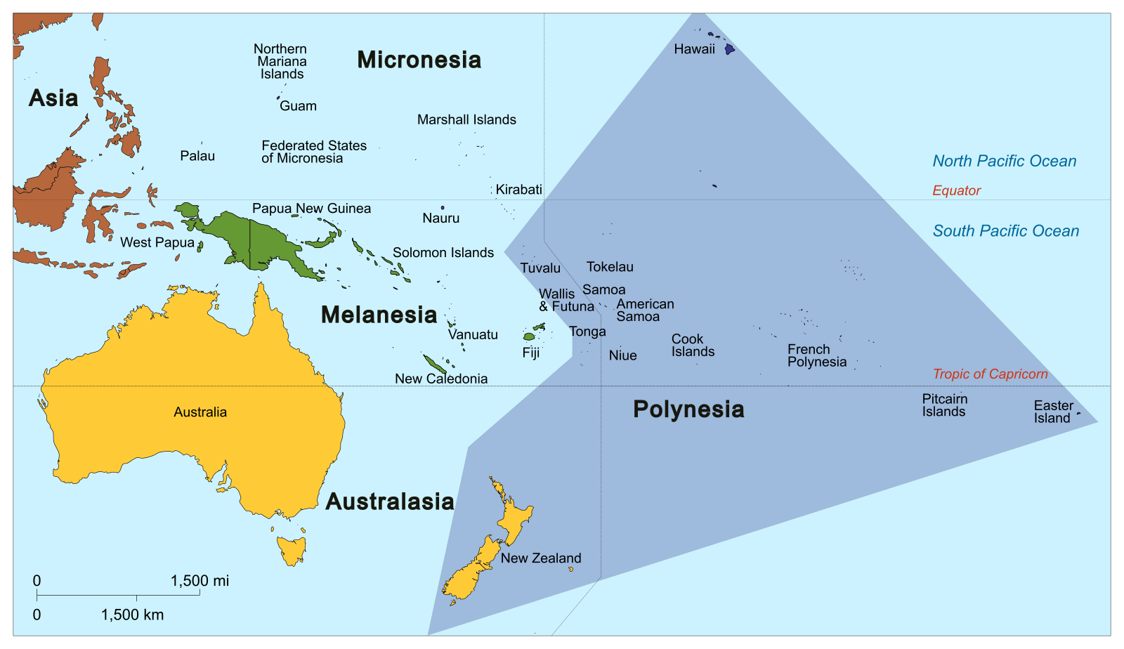
So, what is Polynesia? The Pacific Realm includes Australia, New Zealand, and many other islands. Most of those other islands are quite small. If you consider surface area, then Polynesia is the largest sub-region of the Pacific Realm, with its surface area overwhelmingly being water.

In Greek language, poly means many while nesia refers to islands. So, Polynesia refers to the many islands. These many islands, simplified, are located east of Micronesia and Melanesia. Some of these islands are volcanic – Hawaii is, while many are coral-based low islands.
Even so, Polynesia mainly is a culturally-based region that commonly featured matrilineal societies. Their languages fall in the Austronesian language family, but are in a sub-group distinct from Melanesia and Micronesian sub-groups. Skilled navigation using outrigger canoes propelled natives throughout islands in the vast ocean spaces of Polynesia. Following the arrival of Christian missionaries in 1820, Christianity spread quickly and widely throughout the region.
The native presence on Hawaii extends back at least to 800AD, perhaps longer. European arrival was initially chronicled with the landing of British ships led by Captain James Cook in 1778. King Kamehameha I ruled from 1782 to 1819 and succeeded in unifying the islands.
After a controversial coup overthrowing the Hawaiian Queen Lili’uokalani in 1893, the United States annexed Hawaii by treaty in 1898. It remained a territory of the United States, until joining the union as the 50th state on August 21, 1959. Obviously, in political terms this means that Hawaii is in the region of North America, as it politically is part of the United States. This inclusion of Hawaii in North America is plausibly, for nothing but ocean exists between the American mainland and the Hawaiian Islands.
Public Domain.
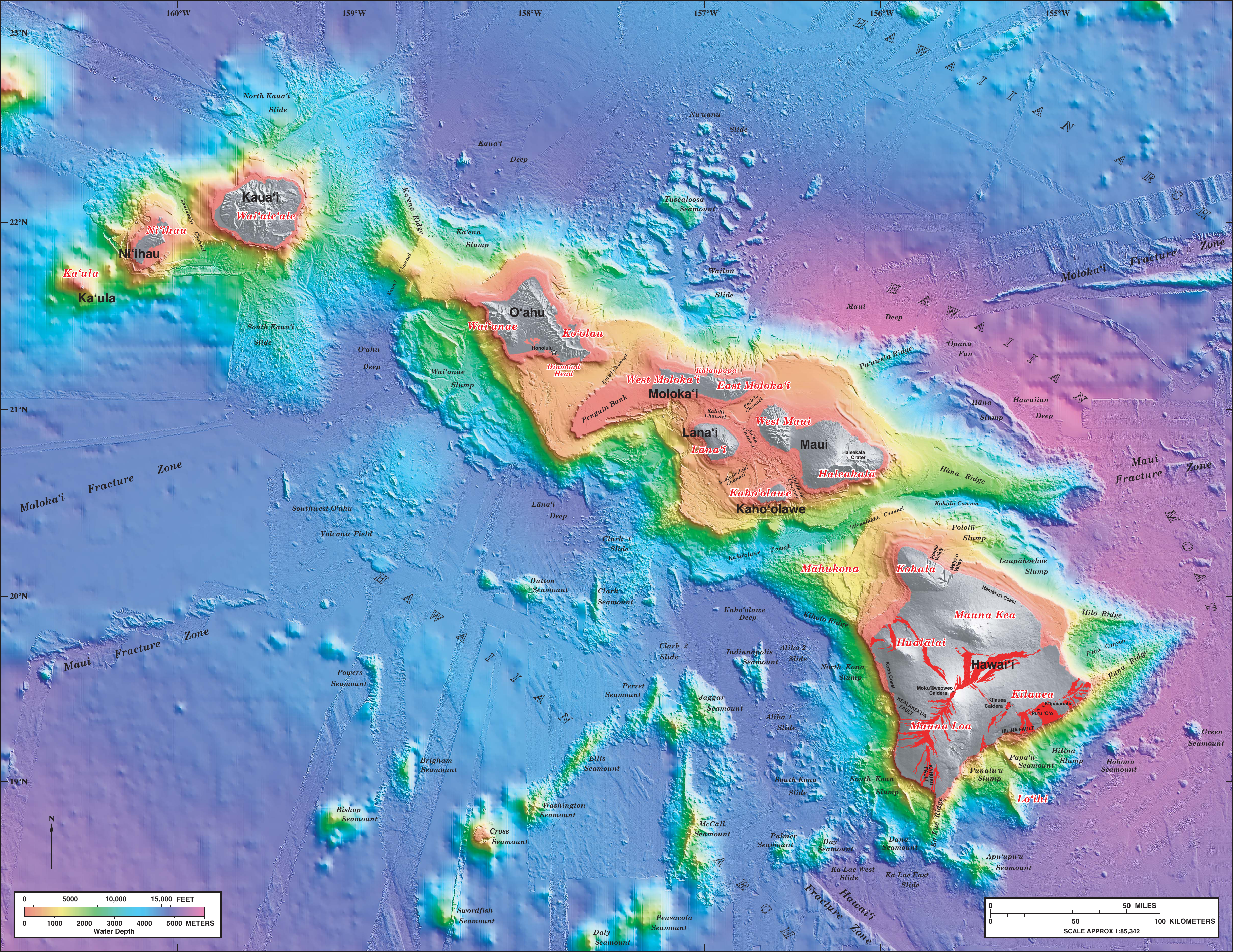
Although there are many volcanic islands in the Pacific Ocean, Hawaii’s formation is unusual, being the “hot spot.” A weakness in the Earth’s mantle, a hot spot, releases molten rock material from the ocean’s floor. This volcanic material accumulates as long as the hot spot remains open. If that time frame is long enough, the hot spot constructs a volcanic island. Additionally, continental drift keeps happening. The hot spot builds an island, but eventually seals off. Continental drift moves the island along. Staying in the original location, the hot spot reopens and builds another island. And so on, over long geologic time frames. Thus, Hawaii is a string of volcanic islands of different ages.
For a handful of European colonial powers, it is difficult to accept that their far distant holdings are part of Europe. For instance, French Guiana remains a part of overseas France, but lies on the mainland of South America. It would seem geographically unacceptable to include French Guiana as part of Europe, even as the European Space Agency’s launch site is located there. Similarly, the islands of French Polynesia are part of France, but are halfway around the world from Europe.
As well, could the Falkland Islands of the coast of Argentina be considered in Europe, because they belong to Britain? Or Pitcairn Island in Polynesia?
Like Hawaii, Easter Island in Polynesia also possesses a dual identity that is geographically palatable. Easter Island, famous for its stone statues – moai – is located in the far southeastern corner of Polynesia, fitting the usual elements of this region. However, the island was annexed by Chile in 1888, though the Chilean mainland is over 2000 miles away over unblocked Pacific waters (similar to Hawaii and the American mainland).
The United States has additional territories among Pacific islands. For instance, Guam and the Northern Mariana Islands are US territories; therefore, they are like Hawaii with dual identities.
Did You Know?
What other places might be considered to have dual identities? With plausible regional inclusion?
- Greenland is an autonomous piece of Denmark and thus Europe, while sometimes being considered part of North America due to its physical landscape location.
- Ecuador’s Galapagos Islands are over 500 miles west of the mainland, but are not considered part of Polynesia.
- The Canary Islands of Spain are directly west of Morocco and thus are in North Africa, but politically belong in Europe, being part of Spain.
- Alaska clearly is separate from the main portion of the United States, thus lacking contiguity. However, by bordering Canada as part of the continental land mass, Alaska clearly is part of North America. It simply is an exclave of the United States.
Cited and additional bibliography:
Cruickshanks. 2014. “Polynesia.” Wikipedia. https://commons.wikimedia.org/wiki/File:Oceania_UN_Geoscheme_-_Map_of_Polynesia.svg. Creative Commons Attribution-Share Alike 3.0 Unported.
a portion of land that is owned by a country, yet is separate from the main portion of that country (for instance, Alaska)
