66 Latin America and the Caribbean (LACAR)
How do we define this region?
As Latinos, we are many, and our geography is gigantic.
– J Balvin, Colombian musician
Regional geography studies the people and places of a cohesive region. A “region” is defined to be an area with multiple shared characteristics over a range of categories, including both physical and human geographic characteristics. The secret of creating a region, which is a human construct not a naturally begotten unit, is to cluster together as many similarities as possible, while excluding geographic differences.
In some cases, the determination of a geographic region is simple. South America obviously is an intact continent, but also possesses many shared features in a variety of geographic categories. In contrast, the region of North Africa and the Middle East (or Southwest Asia and North Africa) is very problematic to create, define, and limit.

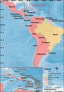
Cartography by Jeff Wandersen
At first glance, the Caribbean may appear to be straightforward to compile as a region. There are logical ways to define Latin America as a region. How do we put them together?
America. To be blunt, that narrows the region quite a bit. We are not talking about Europe or Asia or wherever. Historically, the New World, the Americas.
Latin. The Latin language has long been a dead language; that is, a language that is no longer spoken. However, there are several modern languages that are heavily based on that earlier Latin language. Principally, these modern languages include French, Spanish, Portuguese, Italian, and Romanian. These are European languages, so they must be brought to the Americas. Historically, Italy had colonies, but in Africa, not in the Americas. Romania did not have colonies. France, Spain, and Portugal had colonies around the world, including in the Americas. So, where in the Americas do we currently find French, Spanish, or Portuguese as national languages?

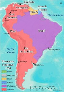
Cartography by Steven Banas
South America:
- Portugal – Brazil
- French Guiana – France
- Spanish – Venezuela, Colombia, Chile, Ecuador, Peru, Argentina, Bolivia, Paraguay, Uruguay
- Exceptions – Dutch in Suriname, English in Guyana
Central America:
- Spanish – Mexico, Costa Rica, El Salvador, Guatemala, Honduras, Nicaragua, Panama
- Exception – English in Belize
Caribbean islands:
- Spanish – Cuba, Dominican Republic, Puerto Rico (partly)
- French – Haiti, Martinique, Guadalupe, St. Barts, St. Martin, Dominica, St. Lucia
- Exceptions – English in the Commonwealth Caribbean (Antigua and Barbuda, the Bahamas, Barbados, Grenada, Jamaica, St. Kitts and Nevis, St. Lucia, St. Vincent and the Grenadines, Trinidad and Tobago), in British Overseas Territories (Anguilla, Bermuda, British Virgin Islands, Cayman Islands, Montserrat, and the Turks and Caicos), in Sint Maarten, and in US territories (US Virgin Islands and partly in Puerto Rico) and Dutch (and Papiamento) in Aruba, Bonaire, Curacao, Saba, Sint Eustatius, and parts of Sint Maarten.
Of course, along with language, the French, Spanish, and Portuguese conquerors and settlers brought many other aspects of culture, economy, and politics with them. We see these elements, mixed to varying degrees with native cultures, throughout Latin America.
Contiguity. For the South American landmass, it is simple to count it as part of Latin America. For the Latin-based languages, there are only two exceptions – Dutch in Suriname and English in Guyana. Can either of those small countries be placed in any other region? Europe? Obviously not. Europe is on the other side of the Atlantic Ocean. In any sense Caribbean? No, both border the Atlantic Ocean directly, not the Caribbean Sea. As both countries are contiguous within South America, while not being contiguous with any other region, both must be counted as part of Latin America, thereby making all of South America to belong in South America.
In Central America, we have a similar situation. Only Belize, an English-speaking country, fails to fit the Latin heritage. Belize too fails the contiguity test. There is no other region for Belize to fit. All of Central America goes into Latin America.
All right then, what about the Caribbean islands? This is a more difficult situation to assess. Other than some contributions to the Papiamento language, the Portuguese played almost no role in the Caribbean. The islands controlled by the Spanish and the French easily are outnumbered by the islands colonized by the English and the Dutch. Would we want to designate some of the Caribbean islands into Latin America, while excluding other Caribbean islands? That would be awkward. If some Caribbean islands are excluded, then into what region are they placed? Could Jamaica and the Bahamas be included in North America? With North America being defined as the United States and Canada, two huge land areas, it would seem awkward to add small island countries to that exclusive group.
What else can be done with these islands? The compromise is expressed in how we state the name of the region – Latin America and the Caribbean (LACAR). The word “and” indicates that these two regions are not the same single region, while the grouping into one phrase infers that there is a broader connection between these two regions. Outside of North America, together these regions are the lands of the New World that were explored, conquered, and settled by European colonial powers, of both Latin-based and other languages, while mixing with native populations to a significant degree (unlike in the United States and Canada, where the concept of mestizo, a person of mixed native and European parentage, is unfamiliar).

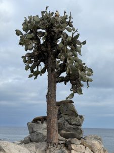
Photo by Karen Egan.
Meanwhile, LACAR does include a few islands in the Pacific Ocean. A very noteworthy example is that Ecuador owns the famed Galapagos Islands, the site of Charles Darwin’s famed expeditions. Note the photo to the left.
Overall then, Latin America and the Caribbean comprise two related sub-regions that are expressed well together. The countries and territories of this combination are gathered together based on contiguity, Latin-based languages, and European colonial acquisitions in the New World.
DId You Know?
Cited and additional bibliography:
Banas, Steve. 2020. “European Colonies in South America, 1763.” College of DuPage GIS class. Instructor Joseph Adduci.
Egan, Karen. 2022. Photo. “Sea lions and Galapagos hawk in the Galapagos Islands.”
Wandersen, Jeff. 2020. “Latin America and the Caribbean.” College of DuPage. College of DuPage GIS class. Instructor Joseph Adduci.

